
El invierno pasado fue un tanto corto y caluroso acá por Bariloche: La nieve empezó a caer a mediados de Julio, para mitad de Octubre las temperaturas estaban bastante altas y la cantidad de nieve era similar a la de mitad de Noviembre del año anterior. En 2015, en cambio, estábamos esquiando a mitad de Junio... Todo esto hizo que en 2016 tuviéramos unos tres meses de esquí, contra unos cinco el año anterior.
Sin embargo, esta temporada tuve la suerte de esquiar algunos volcanes que tenía en la lista: Lonquimay, Llaima, Lanín y Tronador. Así que creo que es hora de una actualización de "esquiando los volcanes".
This
past winter was rather short and
hot here in Bariloche: Snow started falling about mid of July, by mid of
October the temperatures where rather hot, and the snow coverage
was similar (even less) than in mid of November the previous year. By
the
way, in 2015 we were skiing at beginning of June... All this meant than
in 2016 we have something like three months of skiing, when the
previous year it were about five months.
Anyway, this season I was lucky enough to go to some volcanoes I was hopping to ski: Lonquimay, Llaima, Lanín and Tronador. So, time for an update on skiing the volcanoes.
 |
| Volcanes al amanecer, desde la cara Este del Lanín. Cerro Peinetas en el medio (este no es un volcán, creo), Llaima al fondo a la izquierda, y el Lonquimay a la derecha, casi en el horizonte Volcanoes at dawn, from Lanín's East face. Peinetas hill in the middle (not exactly a volcano, I think), Llaima at the bottom left, and Lonquimay to the right, almost in the horizon |
 |
| Tierra de volcanes, de izquierda a derecha: Tolguaca, Sierra Velluda (al fondo), Callaqui, Lonquimay y Copahue Volcano land, from left to right: Tolguaca, Sierra Velluda (at the bottom), Callaqui, Lonquimay and Copahue |
 |
| Un poco de tráfico en el Lanín... (foto por Francisco) A little bit of traffic y Lanín... (photo by Francisco) |
 |
| Amaneciendo en Tronador, lástima la vista :-P Sunrise in Tronador, the view it's really a pity :-P |
Resumen de las salidas a los volcanes / Volcanoes skiing summary:
-------------------------------------------
Volcán | Distancia [km] | Subida [m]
Volcano | Distance [km] | Climb [m]
-------------------------------------------
Lonquimay | 11 | 1250
Llaima | 16 | 1600
Lanín | 20 | 2600
Tronador | 33 | 2400
-------------------------------------------
Lonquimay
A mitad de Julio nos fuimos con Martín en un viaje de esquí y escalada por Chile, con la idea de esquiar algunos volcanes y hacer un poco de escalada en hielo en el valle de Yerba Loca, cerca de Santiago de Chile.
Salimos de Bariloche en el primer día bueno de esquí de la temporada, eso no motivaba demasiado, pero teníamos toda una semana de esquí por delante, así que tampoco estaba tan mal. Viajamos hasta Curacautín, un pueblo cerca de los volcanes Lonquimay y Llaima.
Después de un par de días de lluvia, arrancamos para el Lonquimay, en lo que era el primer día "no tan malo" del pronóstico. En el pueblo estaba lloviendo, pero cuando llegamos a la base del centro de esquí de Lonquimay, estaba parcialmente nublado con algunas nevadas esporádicas, tampoco estaba tan mal...
Subimos foqueando por el centro de esquí, a través de unas pendientes bastante amigables, después nos subimos a un filo (de orientación ESE) que nos llevaba a la cumbre, un cráter volcánico con unas cuantas posibles "cumbres". Estaba un poco nublado arriba, así que no estábamos seguros de si esta era LA cumbre, de todas maneras, era hora de bajar, estaba un poco ventoso arriba, así que sacamos las pieles para abajo. Este era mi segundo día de esquí de la temporada, así que ¡se sentía muy bien estar esquiando en una especie de nieve en polvo volada!
Después de una muy buena bajada, estábamos de vuelta en le centro de esquí, un par de vueltas más y estábamos en la base, hora de comer algo y tomar unos mates. En total, fueron unos 11 km y 1250 m de subida, el Lonquimay tiene unos 2800 m.s.n.m., estuvimos tentados en hacer otras subidas para esquiar un poco más, pero después nos acordamos que al otro día íbamos al Llaima, que en los papeles se lo veía como un día más duro, así que mejor guardar un poco de energía.
Lonquimay
At
mid of July, Martín and I went for a trip through Chile with the idea
of ski some volcanoes and try to get some ice climbing in the Yerba Loca valley, near Santiago.
We
departed from Bariloche in the first good day of skiing of the season,
not so encouraging, but we had about one week of skiing ahead, so it
wasn't so bad. We traveled to Curacautín, a town near Lonquimay and
Llaima volcanoes.
After
a couple of rainy days, we headed up to Lonquimay, in what was the
first "not so bad" day of the forecast. In the town, it was raining some
bit, but when we arrived to the base of Lonquimay, a ski center, it was
partially cloudy with some light snowfall, not so bad...
We
skinned through the ski center, following moderated slopes, and then
got in a ridge (ESE orientation) which led to the summit, a volcano
crater with a lot of possible "summits". It was rather cloudy, so we
weren't sure that this one was THE summit, anyway, time to go down, it
was kind of windy up there, so we transitioned to skiing and down we
went. This was my second day of skiing of the season, so it felt good to
be making some turns in a kind of wind blown powder snow!
After
some good skiing we were back in the ski area, some turns more and we
were back at the base, ready for a lunch with some mates. In the end, we
climbed about 1250 m and traveled about 11 km, Lonquimay tops out at
about 2800 m.a.s.l. We were tempted with making some more laps, but we
decided to save some energy for tomorrow, we were going to Llaima
volcano, which looked like a longer and tougher day.
 |
| Largamos la temporada de volcanes, vamos que se despeja... Volcanoes season is on, it may clear out... |
 |
| Escala de azules, ya casi se despeja... Bluescale, clouds are almost gone... |
 |
| O quizás no se despeja... No se deja ver la cumbre... Or may be they'll stay there... Summit is covered... |
 |
| Ahora sí sale el sol... Ya casi arriba del todo del centro de esquí (foto por Martín) The sun is shining... Almost atop of the ski center (photo by Martín) |
 |
| Y no, parece que vuelve la nieve... And no sun shining, the snow is back... |
 |
| Finalmente, cumbre a la vista (foto por Martín) Finally, summit on sight (photo by Martín) |
 |
| ¡Cumbre!, espero, porque no se ve mucho más lejos... Summit! I hope, the visibility is about 10 meters... |
 |
| ¿Cómo pinta esa bajada? (foto por Martín) How's that skiing looking? (photo by Martín) |
 |
| Primera bajada de la temporada, nada mal eh... First ski of the season, not to bad eh... |
Llaima
Al otro día, salimos para la base del Llaima. El viaje fue un poco más largo y la nieve que cayó esa noche le agregó un poco de tensión (y tiempo) a la aproximación. Las pendientes del centro de esquí son muy suaves, pero cuando se termina el centro de esquí, el terreno se torna totalmente plano (incluso para abajo)...
El paisaje es como un desierto de nieve, con dunas y todo. Desde ahí, foqueamos algo así como unos 3 km hasta que empezó la subida de verdad, para ese entonces ya era ¡hora de almorzar!
La nieve pintaba buena, había alguna acumulación de los días anteriores, pero no tanto como esperábamos (¿dos metros?), lo cual era bastante bueno desde el punto de vista del peligro de avalanchas. Después de comer, encaramos la pendiente principal (por el filo NO) hacia la cumbre, en un típico estilo volcánico: De repente te das cuenta que estás en una pendiente de treinta y pico de grados, haciendo conversiones en la nieve dura, y la pendiente solo se pone más parada, así que ¡mejor no caerse! En los últimos, por decir, 80 m de desnivel, nos sacamos los esquíes y caminamos hasta la cumbre del Llaima, esquivando manchones de piedras calientes, lo cual complicó un poco una esquiada desde la cumbre exacta.
Después de algunas fotos, abrazos y contemplación, empezamos la bajada, no nos quedaban demasiadas horas de luz. Esquiamos la pala más grande que se ve desde el centro de esquí (cara ONO), la nieve arriba estaba un poco dura y volada por el viento, pero después de un par de curvas mejoró bastante. La pendiente estaba interesante, un tanto empinada, y no me ayudaba que fuera mi tercer día de esquí de la temporada, pero después de un par de vueltas me acostumbré al ángulo de la pendiente. Igual, como siempre, mejor no caerse...
Más rápido de lo que hubiéramos querido, ya estábamos de vuelta en la parte plana, la parte de la esquiada siempre parece poco :-) Después de transpirar un poco en el plano, estabamos de vuelta en el centro de esquí, y finalmente en el auto después de unas vueltas más. La verdad que fue un muy buen día de esquí, claramente más intenso que el del día anterior. En total fueron unos 16 km y 1600 m de subida en unas siete horas.
Llaima
The
next day, we headed toward Llaima ski center base. The driving was
longer than the one to Lonquimay, and the snow fallen the previous night
added some spice (and time) to the approach. The slopes inside the ski
area were rather gentle, but at the top of the last ski lift, they
turned out to be totally flat (even downwards)... The landscape is like a
snow dessert, including some dunes. From there, we skinned about 3 km
until the climb really started, by that time it was lunch time!
The
snow looked good, there was some accumulation from the previous days,
but not so much as we initially thought (2 m?), which was better from an
avalanche hazard point of view. After the lunch, we headed toward the
main slope (NW ridge) which led us to the summit, in a typical
volcano way: Suddenly you realize that you are in a thirty odd slope,
doing kick turns in hard wind blown snow, and the slope only gets
steeper, so you better not fall! In the last, say, 80 m, we switched to
booting, and ended up in Llaima summit, around some patches of hot
rocks, which made an exact summit descent rather complicated.
After
some pictures, hugs and contemplation, we started the way down, there
weren't so much hours of light left. We skied the main bowl which can be
seen from atop of the ski center (WNW face), the snow was wind
blown at the top, but after some turns it got better. The slope was
rather steep, it didn't helped that this was my third ski day of the
year, but after some turns I got used to the slope angle. Anyway, as
usual, better not to fall here...
Sooner
than what we have wanted to, we were at the flat snow dessert again,
the ski down always seems like to little :-) After some sweating in the
flat ground, we were again at the ski center, some more turns and back
to the car. It was a really good skiing day, clearly more intense than
the previous one. In total, it was about 1600 m of climb, 16 km and
seven hours on the move.
 |
| Entrando en calor en el centro de esquí Warming up in the ski center |
 |
| Ahí va asomando el Llaima Llaima is showing up |
 |
| Dunas de nieve Snow dunes |
 |
| Disfrutando Enjoying |
 |
| La planicie... The flatlands... |
 |
| Es para arriba (foto por Martín) The way is up (photo by Martín) |
 |
| Almuerzo Lunch break |
 |
| Las pasas de uva no pueden faltar (foto por Martín) Raisins are always present (phto by Martín) |
 |
| Volcanes y más volcanes, de izquierda a derecha: Tolguaca, Callaqui, Lonquimay y Copahue, humeando Volcanoes and more volcanoes, from left to right: Tolguaca, Callaqui, Lonquimay and Copahue, smoking |
 |
| Cambio de punta, dale Tincho nomás Changing leads, come on Tincho |
 |
| La lista de volcanes no para de crecer... The volcanoes list doesn't stop growing... |
 |
| Calentitas, las piedras... Pretty hot, those rocks... |
 |
| Conversión Kick turn |
 |
| Se va poniendo la pendiente... The slope is getting steeper... |
 |
| Y una subida más... Mejor caminar... And one last climb... Better switch to walking... |
 |
| Disfrutando la cumbre, en realidad faltan dos metros de nieve derritiéndose por el calor de los vapores, no sería lo más seguro para subirse... Pero bueno, después de pensarlo unos minutos, no nos quedó otra opción que pararnos ahí arriba. Enjoying the summit, or almost there, there are two meters of melting snow to go, it would not be the safest thing to do to climb them... But, after thinking about it for a couple of minutes, we decided to step over it. |
 |
| Más volcanes para el sur: Lanín, Quetrupillán y Villarrica More volcanoes to the south: Lanín, Quetrupillán and Villarrica |
 |
| ¡Cumbre! Summit! |
 |
| Y todavía más volcanes, Sierra Nevada en el medio, para la próxima quizás And yet more volcanoes, Sierra Nevada at the center, may be for the next time |
 |
| ¡Dale Tincho! Come on Tincho! |
 |
| Buena bajada eh... That was a good skiing eh... |
 |
| Buena nieve, por momentos (foto por Martín) Good snow, for some moments (photo by Martín) |
 |
| De vuelta a las pampas, ¿trajimos los esquíes de fondo? Back to the flatlands, did we got the cross-country skis? |
 |
| Y de vuelta a la civilización, algo de luz queda... And back to civilization, there is some daylight left... |
 |
| Más o menos por ahí, la línea de bajada More or less there, the line we skied |
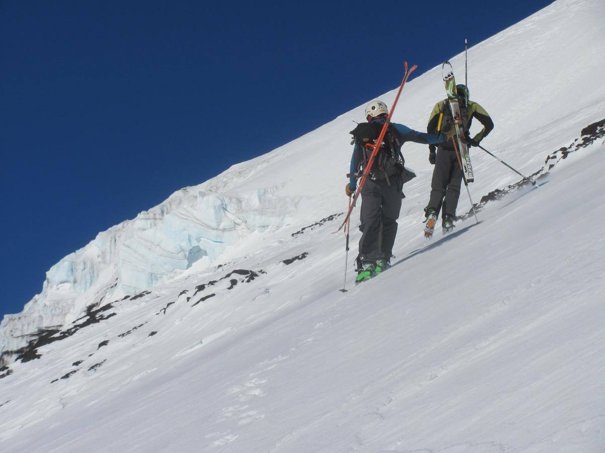
Lanín cara Easte
Como escribía hace un año, tenía ganas de intentar esquiar la cara este del Lanín. Esa es la cara que se ve cuando estás llegando a la base del Lanín desde el norte, por el paso Mamuil Malal. Así que ahí fuimos, esta vez eramos un equipo de cinco: Martín, el Pájaro, Pablo, Francisco y yo. Estábamos pensando en hacer el ascenso en el día, porque tres de nosotros teníamos que trabajar el sábado, así que la idea era viajar el sábado por la tarde a Lanín, comer algo, dormir una siesta, y empezar a movernos tipo tres de la mañana. El pronóstico para el domingo era bastante bueno, poco viento, ni muy frío ni muy caluroso.
Empezamos a caminar a eso de las 3 am, después de unos 45 minutos encontramos unos manchones de nieve, cambiamos a esquíes y empezamos a foquear. El año anterior, me había puesto los esquíes literalmente al lado del auto, pero la cantidad de nieve este año era claramente distinta, no tuvimos tanta suerte.
Ni bien empezó la nieve, Martín picó en punta buscando la línea de subida, como ninguno de nosotros había subido por acá antes, había cierta incerteza sobre el camino exacto de subida, pero como suele pasar en los volcanes: Es para ARRIBA.
Después de unas dos horas, ya habíamos ganado unos 1000 m de desnivel, de un total de aproximadamente 2600 m, una estimación optimista nos daba que entonces en tres horas y media más estábamos en la cumbre (menos de cinco horas de subida), lo que claramente no pasó, al final fueron unas nueve horas de subida. Este tipo de estimaciones siempre suelen ser un tanto optimistas... Esto sin tener en cuenta la altura, la cumbre está a unos 3800 m.s.n.m
Así que, volviendo a la cara Este del Lanín, a eso de las 5 am, estaba claro que este ritmo de ascenso no era sostenible por el resto del día, así que le aflojamos un poco, al mismo tiempo la pendiente se iba tornando cada vez más y más empinada. Después de un par de patinadas en la nieve dura, todos cambiamos esquíes por grampones, más o menos al mismo tiempo. Ah, casi me olvido: El amanecer nos sorprendió en el medio de la cara este, el cielo estaba prácticamente despejado, así que la vista fue realmente ¡impresionante!.
A unos 3300 m.s.n.m, cambiamos de punta con Martín, y casi instantáneamente la nieve dura se transformó en nieve polvo hasta la rodilla, hora de abrir huella... Unos 300 m de desnivel después, la apertura de huella se hizo sentir, y Martín agarró la punta de vuelta. Para ese momento ya era evidente que la altura me estaba afectando, poco hambre, un poco de nauseas y mucha menos energía.
En los últimos 200 m de subida, parecía que la pendiente cedía un poco, así que intenté volver a foquear, lo que cual no funcionó, así que de vuelta a caminar, un par de metros más de escalones y estábamos en la cumbre. Ahí nos encontramos con otro grupo que había subido por la ruta normal, estaban un tanto sorprendidos de ver gente asomando por "el otro lado", y más aun con esquíes al hombro...
Resulta que habíamos estado subiendo toda la mañana por la cara este, reparados del viento, incluso sobre el final se puso caluros, pero cuando llegamos a la cumbre el viento nos hizo recordar que estábamos a 3800 m.s.n.m. Después de alguna fotos, un poco de charla y comida, emprendimos el regreso.
A esta altura, Francisco estaba tratando de convencerme de que esquiáramos la línea que yo había visto en las fotos y películas, algo así como bajar la gran canaleta de la cara este. La idea sonaba interesante, de hecho era la línea que yo quería esquiar, pero el manto de nieve estaba un tanto fino, no estaba del todo claro por dónde entrar a la línea, y yo estaba bastante cansado de la subida en el día, así que decidimos que era una mejor idea esquiar la misma línea de subida, que parecía esquiable sin muchas complicaciones.
Los primeros metros de bajada estaban bastante empinados (quizás unos 40 grados), pero la nieve era buena, así que bajamos hasta unos 3200 m.s.n.m esquiando con bastante cuidado. A esta altura, la pendiente aflojaba un poco, la nieve se iba transformando en una nieve primavera casi perfecta, así que la esquiada se puso muy disfrutable. El equipo venía bien, parando cada tanto a recuperar un poco las piernas, no estábamos acostumbrados a esquiar tanto sin parar. Durante toda la bajada, el Pájaro se quejaba de que no podía esquiar bien, que los esquíes se sentían raros, no los podía controlar. Después de la última vuelta, cuando nos sacamos los esquíes para caminar, cayó en la cuenta de que ¡nunca había trabado las botas para la bajada!, realmente una lástima, pero ¡subimos de vuelta si querés! Nah, era un chiste, capaz la temporada que viene...
Al final del día largo, fueron unos 20 km, 2600 m de subida, 9:30 hs de subida y 2:30 hs de bajada. Como siempre, la esquiada pareció muy corta, ¡pero que buena estuvo la salida! Antes de relajarse, acuérdense que tenemos que desarmar el campamento y volver a Bariloche, unas cuatro horas de viaje, ¡gracias Pablo por la manejada!
Lanín East face
As
I wrote one year ago, I wanted to ski Lanin's east face. That is the
face that you see when you are heading Lanín through Mamuil Malal road.
This time we were a team of five: Martín, el Pájaro, Pablo, Francisco
and I. We where thinking of a one day ascent, since three of us had to
work on Saturday, so the idea was to travel on Saturday afternoon, get
some food, a short nap, and start moving about 3 am. The forecast for
Sunday was good, little wind and not too hot or too cold.
We started walking about 3 am, after about 45 minutes we reached some patches of snow, and transitioned to skinning hopping that the patches were continuous. The past year, I started skinning literally besides the car, this year the snow coverage was quite different, and we weren't so lucky.
Right at the beginning of the snow, Martín took the lead choosing the line of ascent, since none of us had made this route before, there was some uncertainty in the exact path to follow, but as generally happens in the volcanoes, the way is UP.
After two and a half hours, we had gain about 1000 m, of a total of about 2600 m, so an optimistic estimation predicted that will be in the summit in about three and a half hours (less than five hours of climb), which indeed it didn't happened, it took us a total of about nine hours. This kind of calculations tend to be too optimistic... Nevermind neglecting the effect of altitude, the summit is about 3800 m.a.s.l.
So, going back to Lanín's east slope at night, after about two hours, it was clear that our fast climbing pace was unsustainable for the rest of the day, so we eased it up a little bit, and at the same time the slope angle was getting progressively steeper and steeper. After some slides in the hard snow, all the team decided to change skinning for walking, sooner or latter. I almost forgot to mention it: The sunrise got us in the middle of the east face, the sky was mostly clear, so the view was really impressive!.
At about 3300 m.a.s.l., Martín and I switched leads, and almost instantly the hard snow transformed to knee deep snow, time to open up trail... About 300 m of elevation later, I was really exhausted from the trail opening task, so Martín took the lead again. At that time it was clear for me that I was staring to experience the effects of altitude.
The last 200 m to the summit looked a little less steep than the previous one, so I tried skinning again, which didn't work, so after the final meters of stairs walking, we were at the summit. We met another team who was climbing through the normal route, they were quite amazed of seeing people coming up from "the other side" of the summit, moreover with skis in their packs...
It turned out that we had been climbing all morning away from the prevailing west wind, in fact the last climb was rather hot, but at the summit the cold wind reminded us that we were at about 3800 m.a.s.l. After some pictures, chatting and eating, we got ready for the descent. At that time, Francisco asked me to join him to descend the line we'd scoped in the picture, something like skiing the big east facing chute.
The idea was interesting, in fact that was the line that I wanted to ski, but the snow coverage was rather thin, it wasn't completely clear were to enter the line, and I was rather tired from the one push climb, so we decided to just ski down the same line that we had climbed, which looked skiable without too much trouble. The first meters where quite steep, but the snow was good, so we managed to get to about 3200 m.a.s.l. skiing whit some care. At that point, the slope angle started to ease, and the snow transitioned to perfect spring corn, so the skiing was really enjoyable. The team was going good, just needing to stop to regain some muscle strength, we weren't used to ski for so long a run. All the way down, Pájaro was complaining that their skis felt like wired, not being able to control them as usual. After the last turn, when we switched to walking, he realized that he had forgotten to put his boots in "ski mode", really a shame, but we could climb it back! Nah, just kidding, may be the next season.
In the end, the long day was about 20 km, 2600 m of climb, 9:30 hr going up and 2:30 hr going down. As usual, the skiing time seemed too short, but what a good day in the mountains! Before relaxing, remember we had to go back to Bariloche, about 4 hs of drive, thanks Pablo for the driving task!.
 |
| Arrancando temprano... Early start... |
 |
| La cara este va asomando, igual que el sol The east face is raising, like the sun |
 |
| ¿Amanecer? En un par de minutos... Sunrise? In a couple of minutes... |
 |
| Amanecer (foto por el Pájaro) Sunrise (photo by Pájaro) |
 |
| El ángulo de la pendiente, que no para de crecer... The slope's ever growing angle... |
 |
| Descansando un poco en la piedrita (foto por el Pájaro) Finding some rest in that little stone (photo by Pájaro) |
 |
| Momento de sacar fotos Picture time |
 |
| Va asomando la cara Este, la canaleta del medio es la que sale en este video, nosotros subimos por la izquierda, sobre la banda de rocas The East face starts to show up, the chute in the middle is skied in this video, we climbed to the left, atop the band of rocks |
 |
| Fran y el sol Fran and the sun |
|
| No me canso de los amaneceres... I don't get tired of sunrises... |
 |
| Hora de caminar, muy dura la nieve para foquear (foto por el Pájaro) Walking time, to hard snow for skinning (photo by Pájaro) |
 |
| Pablo posando, y el Pájaro Pablo pssing, and Pájaro |
 |
| Y un poco más arriba... (foto por Pablo) And some steps more up... (photo by Pablo) |
 |
| Pablo y yo, y la pendiente (foto por el Pájaro) Pablo and I, and the slope (photo by el Pájaro) |
 |
| ¡Dale Tincho! (foto por el Pájaro) Come on Tincho! (photo by Pájaro) |
 |
| Seguro que foquear es una idea buenísima.. O capaz que no... (foto por el Pájaro) Sure skinning it's a good idea... Or may be not... (photo by Pájaro) |
 |
| ¿Escalera al cielo? Stairways to heaven? |
 |
| Siguiendo los pasos, literalmente, ¡gracias Tincho! (foto por Pablo) Following the steps, literally, thank you Tincho! (photo by Pablo) |
 |
| La foto de la foto, ¿hace calor Martín? (foto por Pablo) Picture in picture, it's getting hot Martín? (photo by Pablo) |
 |
| Los últimos pasos... (foto por el Pájaro) The last steps... (photo by Pájaro) |
 |
| ¡Cumbre! El Villarrica de fondo (foto por el Pájaro) Summit! Villarrica at the background (photo by Pájaro) |
 |
| "Ritmo latino en la cara Este" (?) |
 |
| ¡Abrazo de cumbre! Summit's hug! |
 |
| Martín mirando la bajada (foto por el Pájaro) Martín scooping the way down (photo by Pájaro) |
 |
| Se va poniendo la pendiente... Estimación del ángulo bajando de la cumbre, igual, no bajamos directamente por esa línea... The slope is getting steeper... Angle estimation of the summit slope, anyway, we didn't skied exactly that line... |
|
| En fila, ¡no vale caerse! (foto por Francisco) Stay in line, you're not allowed to fall! (photo by Francisco) |
 |
| ¡Dale Frán! Come on Fran! |
 |
| ¡Ya casi llega la nieve primavera! (foto por Pablo) The spring snow is almost there! (photo by Pablo) |
 |
| ¡Estalló el verano! Summertime! |
 |
| Relajate... No auspiciado por Hagan (foto por el Pájaro) Relax... Not sponsored by Hagan (photo by Pájaro) |
 |
| ¡Dale Pablo! (foto por Martín) Come on Pablo! (photo by Martín) |
 |
| Buscando a Wally, de día es otra cosa... (foto por el Pájaro) Where's Wally?, at daylight is different... (photo by Pájaro) |
 |
| ¡Venga el equipo! De izquierda a derecha: Pablo, yo, Martín, Pájaro y Fran Come on team! From left to right: Pablo, me, Martín, Pájaro and Fran |
 |
| Más o menos por ahí la línea... (foto por Pablo) More or less there the line... (photo by Pablo) |
 |
| Y un poco más de zoom, ¿la canaleta principal? quizás la próxima... (foto por Francisco) And a little bit more zoom, the main chute?, may be next time... (photo by Francisco) |
Tronador, cara Norte del pico Argentino
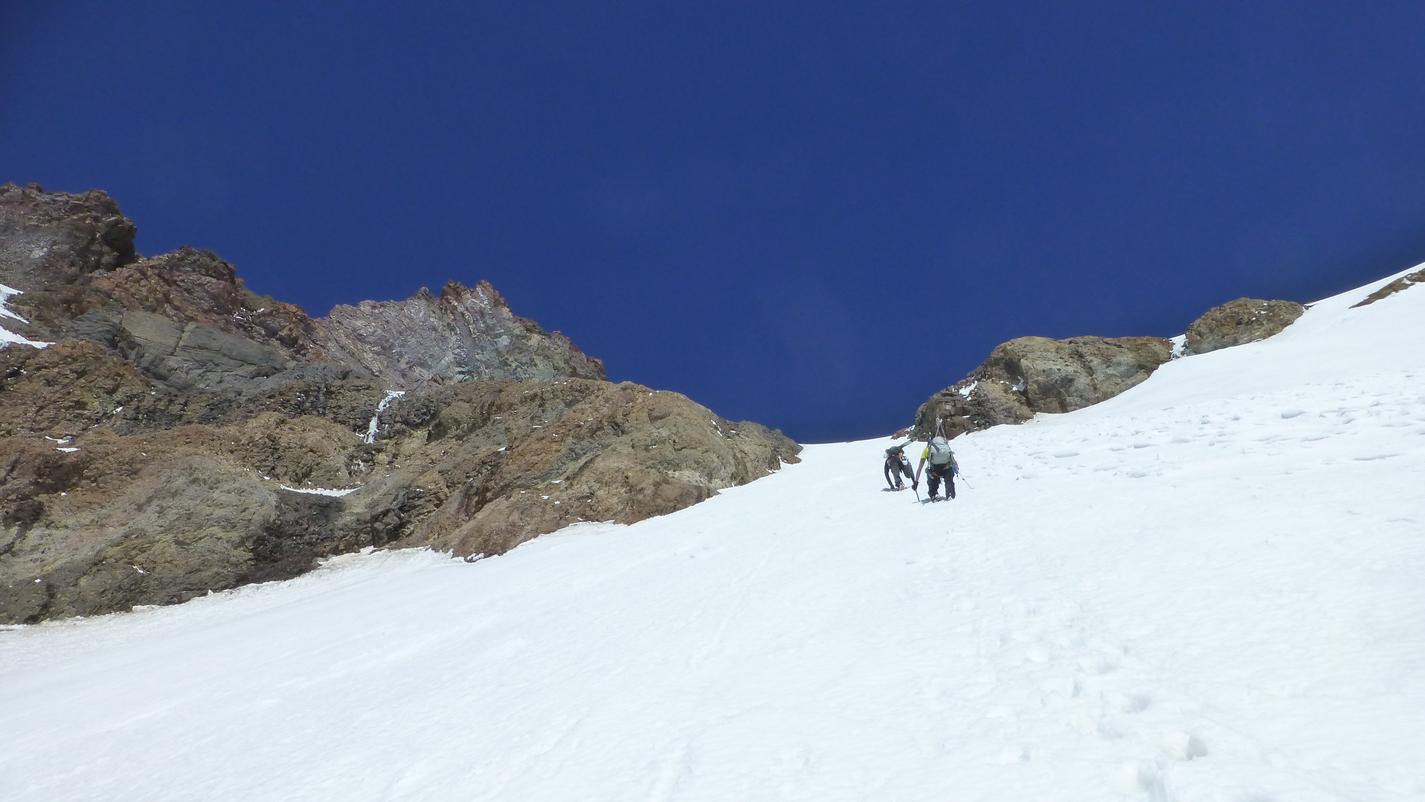
Siguiendo con la lista de volcanes, tenía ganas de esquiar la cara norte del pico Argentino, en Tronador. Martín y el Pájaro también querían ir, pero no terminábamos de encontrar un hueco en nuestros cronogramas, que también tenía que coincidir con un par de días de buen clima y buenas condiciones de la nieve. Finalmente, después de planear un poco, terminamos yendo con el Pájaro, en una salida por el día. A último momento se nos sumo una nueva compañera, Froggy: Ella es checa, vive en Canadá y trabaja como asistente de guía en salidas de heliesquí. Así que el plan era un tanto extraño: Sabíamos que una salida por el día a Tronador iba a ser más dura que lo habitual, y además ahora teníamos una compañera nueva que no conocíamos...
El viaje hasta Pampa Linda fue pasando entre mate y mate, con anéctdotas de por medio (¡más cafeína por favor!). Cuando nos quisimos acordar, estábamos en Pampa Linda acomodando el equipo, en el medio de la noche. Estaba un tanto caluroso para las dos de la mañana, como decía el pronóstico, pero quizás este fin de semana era el último de clima "no tan malo" en las próximas semanas, quizás la última oportunidad de la temporada, así que teníamos que hacer el intento.
Después de un par de horas, llegamos a la Almohadilla, donde la nieve era aceptable para foquear, así que nos pusimos los esquíes. A esta altura, ya estaba claro que iba a tener que apretar para seguirle el paso a nuestra nueva compañera, parece que el equipo puede llegar a funcionar eh...
Foqueamos hasta el refugio, sobre una nieve primavera bastante dura, a estas horas de la noche. Ahí nos pusimos los arneses y comimos algo. Unos minutos más y nos estábamos encordando al comienzo del glaciar, con el sol empezando a asomar por el horizonte, ¡muy buena vista!, creo que me puedo acostumbrar, jeje.
A eso de las nueve de la mañana estábamos en la base de la cara norte, hasta ese momento la parte de buscar el camino venía relativamente fácil, porque ya conocíamos la mayor parte, pero ahora teníamos que buscar una pasada por la cara norte, entre medio de las grietas. Había distintas opciones y opiniones, y todavía nos faltaban unos 700 m de desnivel. Al final, decidimos seguir desencordados, la pendiente era un tanto pronunciada para encordarse, unos 35 grados en promedio, con pasadas de cuarenta y algo de grados. Primero fuimos a la izquierda, esquivando unas grietas bastante grandes, para luego travesear a la derecha, más o menos a la mitad de la pared, desde acá un poco más de travesía a la derecha y hacia arriba, pasando un par de puentes de nieve un tanto dudosos, para al final empalmar con la rampa de nieve hacia la cumbre. Para esta altura, la temperatura había subido bastante, la nieve estaba blanda y pegajosa, y alguna que otra piedra pasaba volando desde arriba, así que queríamos salir de ahí lo antes posible...
En los últimos 200 m de subida, Froggy tomó la punta, pateando escalones en la nieve, yo estaba realmente agradecido, la nieve se me pegaba a los grampones (con antiboot y todo), lo que hacía que cada bota pesara bastante más, y el peso extra se hacía sentir... A eso de la una de la tarde estábamos en la cumbre del pico Argentino, agradecidos de estar lejos de las piedras voladoras en la cara norte, y viendo por dónde bajar.
No fue muy difícil consensuar que NO íbamos a esquiar la cara norte, debido a la caída de piedras y la nieve demasiado blanda (esto sumado a la pendiente de la cara, claramente...), así que decidimos bajar por la ruta normal. Después de un rapel de 20 m, caminamos unos metros hasta un lugar más o menos plano para ponernos los esquíes. Desde ahí, esquiamos hasta el filo de la vieja, en una especie de nieve cartón volada por el viento. Una vez en el filo, una pequeña subida (¡que siempre parece demasiado!) y ahora sí todo para abajo.
Desde el filo de la Vieja hacia abajo, esquiamos un poco de nieve primavera casi perfecta, hasta que nos encontramos con unos diez centímetros de nieve en polvo, caídos el día anterior, que se había convertido en nieve muy pegajosa, así que desde ahí fue una batalla contra la nieve pegajosa para poder deslizar hacia abajo.
Hicimos una parada en el refugio, a eso de las cuatro de la tarde, comimos la comida que nos quedaba y cargamos algo de agua, para luego continuar bajando hacia Pampa Linda. Llegamos ahí a eso de las seis y media de la tarde, algo así como dieciséis horas y media, cansados pero contentos. Hora de unos mates más y un par de horas de viaje hasta Bariloche. Por suerte habíamos dejado unas empanadas en el auto, no estoy seguro si esto era el almuerzo, la cena o el desayuno, pero seguro que necesitaba comer algo. A esta altura del día, tampoco estaba seguro si estabamos hablando español, inglés o qué, pero de una forma u otra el equipo se entendió bastante bien...
En total fueron unos 33 km, 2400 m de subida y 16:30 hs. La verdad que fue una salida muy buena (¡y dura!), conocimos una nueva compañera y una nueva cara del Tronador. La esquiada va a tener que esperar para otro día, y quizás otra estrategia: Subir por la ruta normal al pico Argentino y desde ahí esquiar la cara norte, tratando de elegir un día no tan caluroso.
Tronador, Argentinian's peak North face
Following the volcanoes list,
I wanted to ski the north face of the Argentinian peak in Tronador.
Martín and Pájaro wanted to go too, but we couldn't fit it into our
weekend's schedules, which in turn had to fit with the weather forecast
and snow conditions. After some planing, I ended up heading to Tronador
with el Pajaro, for a one push attempt to the north face of the Argentinian
peak. At the last minute, Froggy joined up (she's a
Czech living in Canada, working at heli-ski tours). So, the plan was
kind of weird: We knew that going for a single push ascent would be
tougher than usual, and now we had a new parter we haven't met yet...
The
drive passed by whit some mates in between (more caffeine please!) and
also did the anecdotes. Sooner than later we were in Pampa Linda,
sorting some gear and walking up in the middle of the night. The
temperatures were rather hot at 2 am in the morning, as the forecast
said, but this was the "less bad" day in the upcoming weekends, and may
be the last one of the season, so we had to give it a try.
After a
couple of hours we arrived to the Almohadilla, where the snow was good
enough for skinning, so we made the transition. At that point, I was full
aware that I'll had to work hard to keep the pace whit our new partner,
it seems that the team may work out...
We
skinned all the way up to the hut, over some hard spring snow, there we
put on our harnesses and eat some bit. Some minutes more and we were
roping up at the beginning of the glacier, whit the sun starting to show
up in the horizon, that was a really good view! I think I can get used
to it :P
About 9 in the morning we where at the base of the north
face, up to there the route finding was relatively easy, mostly in known
terrain, but now we had to find our way through the crevassed north
face. There were some options and deliberation, and we still had about
700 m of height to gain. At the end, we decided to walk up unroped, it
was too steep to rope up, about 35 degrees all the way, with some
passages at about 40 something degrees. First we went to the left,
skipping some big crevasses, at about the middle of the climb, we
traversed right, passing by a couple of dubious snow bridges until
gaining the final snow slopes. At this time, temperatures were already
high, the snow was quite soft, deep ans sticky, and there were some
rocks coming down also, so we wanted to get out of there as soon as
possible...
In the last 200 m of the climb, Froggy took the lead
kicking steps in the snow, I was really thankful for that, the snow was
sticking in my crampons, making each boot weight noticeably more, surely
I could feel that added weight... At about 1 pm we where at the top of
Argentinan peak, grateful to be far away of the flying rocks on the
north face, looking for some food and a way down.
It wasn't too
hard to decide that we were NOT going to ski down the north face, due to
the rock falling hazard and the too soft snow (added up with the
steepness of the face, clearly...), so we opted for the normal route for
the descent. One 20 m rappel and we were walking down a little bit to a
more or less flat spot to put on our skis. From there, we skied down
through a breakable crust snow towards la Vieja ridge, were we had a
short walk up (which always feels like too much!).
Once atop la
Vieja ridge, we got some good turns in spring snow, until we found
powder snow from the previous day which had turned into really sticky
snow, so from there it was a battle against stickiness in order to slide
down!
We took a brake at the hut, at about 4 pm, where we got some
watter and eat whatever food we had left, and continued down towards
Pampa Linda. We arrive there at 6:30 pm, after about 16 and a half
hours, tired but happy. Now it's time to get some more mate and a couple
of hours driving back to Bariloche. Thankfully we had left some
empanadas in the car, I'm not sure if this was launch, dinner or
breakfast, but sure I needed to eat some bit. At this time, I couldn't realize if we were talking in Spanish, English or what, but in some way the team's communication worked out pretty well...
In the end, it was
about 33 km in total, 2400 m of climb and 16:30 hs. It turned out to be a
really good (and tough!) day in the mountains, we got to know a new
partner and a new face of Tronador. The skiing will have to wait for
another day, and may be another approach: Get to the top of Argentinian
peak through the normal rout and from there, ski the north face,
watching for not so hot conditions.
|
| Los beneficios de arrancar temprano... The benefits of an early start... |
 |
| Sesión de fotos al amanecer (foto por el Pájaro) Photo session at dawn (photo by Pájaro) |
 |
| "Hola mamá, ¿a que no sabés de dónde te estoy llamando?" "Hi mom, you'll not guess from where I'm calling" |
 |
| Amanecer de la cordada Ropemates dawn |
 |
| El granito naranja de las agujas de Frey The orange granite of Frey's agujas |
 |
| Equipo de sombras Team of shadows |
 |
| ¿Cómo va eso Pájaro? How's that going Pájaro? |
 |
| Nuevos caminos: a la izquierda, el filo de la Vieja, a la derecha, hacia la cara norte (la pendiente de la derecha) New trails: la Vieja's ridge, to the left, towards the north face, to the right (the ridge at the right) |
 |
| Mar de hielo, el volcán Puyehue al fondo, en el centro Sea of ice, Puyehue volcano at the bottom center |
 |
| La cara norte del pico Argentino, elegí tu camino The north face of the Argentinian peak, choose your path |
 |
| ¿Un tanto empinado para estar encordados? Minutos después, nos desencordamos (foto por el Pájaro) Quite steep for being roped? Minutes latter, we unroped (photo by Pájaro) |
 |
| El Pájaro y Froggy al comienzo de la cara norte, al medio el glaciar Frías y a la izquierda abajo, el Casa Pangue Pájaro and Froggy low on the north face, Frías glacier in the center, and Casa Pangue to the bottom left |
 |
| La travesía a la derecha, a mitad de la subida, había un par de puentes de nieve un tanto finos The traverse to the right, about half of the climb, there were a couple of thin snow bridges |
 |
| Las pendientes de nieve del final, ¡derecho para arriba! (foto por el Pájaro) The final snow slopes, straight up! (photo by Pájaro) |
 |
| ¡Mirá donde pisás! literalmente... (foto por el Pájaro) Watch your steps! literally... (photo by Pájaro) |
 |
| Froggy abriendo huella en los metros finales, ¡muchas gracias! Forggy kicking steps in the last meters, thank you very much! |
 |
| Y más volcanes, de izquierda a derecha: Puntiagudo, Casablanca, Puyehue, Mocho Chosuenco, Villarrica, Quetrupillán, Lanín And more volcanoes, from left to right: Puntiagudo, Casablanca, Puyehue, Mocho Chosuenco, Villarrica, Quetrupillán, Lanín |
 |
| Froggy en la cumbre, ¡esa es la actitud! Froggy at the top, that's the attitude! |
 |
| ¡Buena foto che! Quién escribe llegando a la cumbre del pico Argentino, el pico internacional a la izquierda (foto por el Pájaro) Really nice picture eh! Me getting to the summit of Argentinian peak, international peak at the left (photo by Pájaro) |
 |
| Rapel desde la cumbre, y casi que es ¡hora de esquiar! Summit rappel, and we are almost skiing! |
 |
| Y otra transición más... Cumbre Internacional, el pico Chileno a la derecha, y el Puntiagudo al fondo And one more transition... International summit, Chilenean peak to the right, and Puntiagudo at the bottom |
 |
| ¡Hora de esquiar! Skiing time! |
 |
| Y otra subida más, al filo de la Vieja's, esta siempre duele... And one more climb, to la Vieja ridges, this one is always tough... |
 |
| Sonriendo el filo (foto por el Pájaro) Smiling the ridge (photo by Pájaro) |
 |
| ¡Felicidad! Happiness! |
 |
| ¡Más felicidad! (foto por el Pájaro) More happiness! (photo by Pájaro) |
 |
| Y un par de vueltas más (foto por el Pájaro) A couple more turns... (photo by Pájaro) |
 |
| Adiós, hasta la próxima Goodbye, 'till next time |
 |
| Creo que la foto movida se correlaciona bastante con el nivel de destrucción que tenía a esa altura del fin de semana... Una hora más y estamos... I think the blurred picture is in accordance with my state of destruction at that point of the weekend... One hour more and we are there... |
 |
| 16 horas y media después.... El equipo de vuelta en Pampa Linda (foto por Marcelo) 16 and 1/2 hours later... The team back at Pampa Linda (photo by Marcelo) |
EOP (end of post)
Hola Agustin;
ResponderBorrarSoy Esther, española aunque vivo en el Tirol Austriaco. Estaba buscando información para ascender algunos volcanes de las Araucarias y he encontrado tu blog. Encantada me he quedado. No he encontrado manera de encontrar un contacto para enviarte mail privado y tampoco he podido publicar en tu sección de "Y vos quien sos?" :-).
Pero que menos que señalar que me gustan tus artículos, pensamientos y la información que aportas.
Te invito a que entres en el mío. Se llama APRENDIENDO A ESQUIAR https://esquiesther.blogspot.com
Un saludo!! :-)