
La idea de este viaje me viene dando vueltas en la cabeza desde hace algunos años, cuando mi amigo Martín me contó sobre sus viajes a la Cordillera Blanca de Perú. En los años anteriores, por distintas razones, no pude acompañar a Martín, pero este año no me pude negar. Así que a principios de Julio estábamos viajando a Lima, desde Buenos Aires, justo en la mitad de la final de la Copa América, disputada entre Argentina y Chile (no soy muy fanático del fútbol, como verán...)
Llegando a Huaraz
A eso de las 9 pm llegamos al aeropuerto de Lima, y fuimos derecho hacia la terminal de ómnibus, donde ya habíamos reservado pasajes para el colectivo a Huaraz. Después de un viaje de toda la noche por las rutas peruanas, cruzando un paso de unos 4200 metros sobre el nivel del mar (m.s.n.m.), finalmente llegamos a Huaraz (a unos 3100 m.s.n.m., ver (1) ), y así terminó nuestro viaje de 24 hs.
El 12 de Julio a la mañana llegamos al hostel en Huraaz, cargando un par de bolsos de 30 kg (ver (2) ) . A esa altura, estaba cansado del viaje, pero creía que la altura no me estaba afectando tanto. Había estado un par de veces en altura, en Mendoza, llegando a unos 5400 m.s.n.m. y Martín me había dicho que la altura en Perú no se sentían tanto, así que estaba un poco confiado. Eso fue hasta que la chica del hostel dijo que nuestra habitación estaba en el tercer piso, claramente sin ascensor. Después de tres pasos, me acordé que no tenía que apurarme y de que tenía que respirar... Al final, la pieza estaba en la planta baja, pero el ejercicio sirvió como recordatorio de que no estábamos a nivel del mar, "esto va a doler...". El resto del día nos dedicamos a dormir un poco y pasear por Huaraz.
Empezando a moverse
Al día siguiente nos fuimos a escalar en roca, al sector Los Olivos. Ahí me acordé que estábamos cerca del ecuador: Hacía bastante calor al sol del medio día, capaz que por eso todas las rutas a la sombra estaban ocupadas... Sin embargo, la sensación de andar de maya y remera estuvo buena, sobre todo viniendo de Bariloche donde estaba esquiando hacía una semana. La escalada estuvo bien, pero yo claramente estaba en "cámara lenta" culpa de la altura, y eso que estábamos en el punto más bajo de las próximas dos semanas (en realidad, estuvimos unos 600 m más abajo, camino a la Laguna 69, pero siempre dormimos en Huaraz o más arriba).
In the beginning
The
idea of this trip has been turning around in my mind since some years
ago, when my friend Martín told me about his journeys in the Cordillera
Blanca of Perú. In the previous years, for different reasons, I couldn't
join Martín, but this time I couldn't say no. So at the beginning of
July we were traveling to Lima, from Buenos Aires, just in the middle of
the final game of the "Copa American" football coup, between Argentina
and Chile (I'm not a football fanatic, as you can guess...)
 |
| Vista de Huaraz y la Cordillera Blanca, desde el barrio Los Olivos. Los picos nevados tiene entre 4500 m y 6400 m de altura. Huaraz and Cordillera Blanca view, from Los Olivos. The peaks in the background are about 4500 m ad 6400 m high. |
Llegando a Huaraz
A eso de las 9 pm llegamos al aeropuerto de Lima, y fuimos derecho hacia la terminal de ómnibus, donde ya habíamos reservado pasajes para el colectivo a Huaraz. Después de un viaje de toda la noche por las rutas peruanas, cruzando un paso de unos 4200 metros sobre el nivel del mar (m.s.n.m.), finalmente llegamos a Huaraz (a unos 3100 m.s.n.m., ver (1) ), y así terminó nuestro viaje de 24 hs.
El 12 de Julio a la mañana llegamos al hostel en Huraaz, cargando un par de bolsos de 30 kg (ver (2) ) . A esa altura, estaba cansado del viaje, pero creía que la altura no me estaba afectando tanto. Había estado un par de veces en altura, en Mendoza, llegando a unos 5400 m.s.n.m. y Martín me había dicho que la altura en Perú no se sentían tanto, así que estaba un poco confiado. Eso fue hasta que la chica del hostel dijo que nuestra habitación estaba en el tercer piso, claramente sin ascensor. Después de tres pasos, me acordé que no tenía que apurarme y de que tenía que respirar... Al final, la pieza estaba en la planta baja, pero el ejercicio sirvió como recordatorio de que no estábamos a nivel del mar, "esto va a doler...". El resto del día nos dedicamos a dormir un poco y pasear por Huaraz.
Getting there
We
arrived at Lima airport in the afternoon, about 9 pm, and we head
straight to the buss station, where we had bought tickets to Huaraz in
advance. Following an all night journey through peruvian roads, passing
at about 4200 meters above see level (m.a.s.l.), we finally arrived to
Huaraz (about 3100 m.a.s.l., see (1) ), ending our 24 hr trip.
In
the evening of July 12th we got to a Hostel in Huaraz, hauling our
couple of 30 kg bags. At that point, I was tired by the trip, but
thought that the height's effect was not so bad. I've been climbing a
couple of times in Mendoza, getting up to 5400 m.a.s.l., Martín told me
that the effects of the altitude weren't so bad in Perú as they were in
Mendoza, so I was feeling confident. That was up to the moment when the
girl in the hostel announced that our room was in the third floor,
clearly without elevator. After three steps, I needed to remind myself
to take it easy and breathe... In the end, the room was in the ground
floor, but the exercise served as a reality check, "this is going to
hurt..." We took the day off for resting and wandering around Huaraz.
Empezando a moverse
Al día siguiente nos fuimos a escalar en roca, al sector Los Olivos. Ahí me acordé que estábamos cerca del ecuador: Hacía bastante calor al sol del medio día, capaz que por eso todas las rutas a la sombra estaban ocupadas... Sin embargo, la sensación de andar de maya y remera estuvo buena, sobre todo viniendo de Bariloche donde estaba esquiando hacía una semana. La escalada estuvo bien, pero yo claramente estaba en "cámara lenta" culpa de la altura, y eso que estábamos en el punto más bajo de las próximas dos semanas (en realidad, estuvimos unos 600 m más abajo, camino a la Laguna 69, pero siempre dormimos en Huaraz o más arriba).
Starting to move
The
next day we went rock climbing near Huaraz, in Los Olivos. There I
realized we were near the equator: It was quite hot in the sun, at
midday, maybe that was why all the routs in the shadow where occupied...
But it was a good sensation to be in shorts, coming from the winter in
Bariloche where I was skiing a week ago.The climbing was good, but I was
definitely in "slow motion" due to the elevation, which would be our
lowest point for the next four weeks (in fact, we were about 600 m lower
in the bus, traveling to lagoon 69, but we always slept at or above
Huaraz elevation).
La idea para la primer semana era hacer algunas salidas tranquilas por el día. Así que fuimos hacia la Laguna 69, una caminata clásica de la zona. Esta caminata es más un paseo en colectivo que caminata (unas seis horas de viaje en total), pero los paisajes son realmente increíbles. La ruta te lleva hacia el norte por el valle del río Santa, pasando cerca del Huascarán Norte y Sur (la montaña más alta de Perú), y también por los pueblos de Huaraz, Carhuaz y Yungay, entre otros. Yungay fue destruido por una avalancha y alud en 1970: Un terremoto rompió parte del glaciar en la cara oeste del Huascarán Norte, esto provocó un alud que literalmente sepultó el pueblo de Yungay, los únicos sobrevivientes se encontraban en el cementerio, que es la parte más alta del pueblo.
 |
| Valle de Llanganuno, en azul la caminata a Laguna 69 y refugio Perú. Llanganuco valley, in blue the trek to Lagoon 69 and Perú hut. |
En Yungay el colectivo dobla a la derecha y empieza a subir por el valle de Llanganuco; desde la ruta hay unas vistas impresionantes de los Huandoy, Huascarán, Chopicalqui y Yanapaqcha, entre otros.
 |
| Caminando hacia la Laguna 69, con el Chacraraju de fondo. Going up to Lagoon 69, Chacraraju at the bottom. |
Después de unas cuatro horas de viaje, el colectivo nos dejó en el comienzo de la picada a Laguna 69 y refugio Perú (derecha o izquierda). Estas dos caminatas son bastante populares, la laguna 69 está a unas dos horas y media de caminata y te deja justo debajo de la impresionante cara sur del Chacraraju, la otra picada te lleva al refugio Perú, el punto de partida para Piso y los Huandoy.
 |
| Laguna 69 y la cara sur del Chacraraju. Hacia atrás, el camino al refugio Perú, a la derecha, el camino de subida a la laguna. Lagoon 69 and the south face of Chacraraju. Back from the photo, the path to Perú refugee, at the right, the common route to the lagoon |
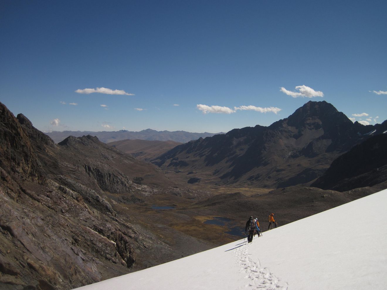
Según nuestros planes, la idea era hacer una caminata tranquila para ir acostumbrándonos a la altura, la laguna está a unos 4600 m.s.n.m., pero mirando el mapa encontramos un camino que unía la laguna con el refugio Perú. El camino parecía una travesía sin mucha subida, así que después de algunos cálculos (optimistas) sobre tiempo y distancia, nos decidimos por el camino más largo. La otra opción era volver por donde vinimos, que era el camino más corto. No teníamos demasiado tiempo, porque el colectivo nos esperaba en la ruta a las cuatro de la tarde, y ya estábamos pasando el medio día. Después de unos minutos de caminata estaba claro que nuestros cálculos eran demasiado optimistas (hicimos las cuentas como si estuviéramos a 2500 m.s.n.m.) y el camino tampoco era tan plano, tenía algunas subidas y bajadas, y sobre todo este se suponía que era el día "tranquilo"... Pero, "ya casi estamos", así que seguimos en dirección al refugio Perú. Los paisajes en el camino son espectaculares, se ven las paredes de los Huandoy y la ruta normal al Pisco, realmente impresionante las vistas.
 |
| Los Huandoy de fondo, sur, oeste, norte y este. A mi se me acabó la nafta, y todavía falta bajar... (Foto por Martín) The Huandoy's at the back, south, west, north and east. I've ran out of fuel, and we still have to go down... (Photo by Martín) |
Cuando llegamos al refugio Perú se nos estaba acabando el tiempo (eran las tres de la tarde), y yo no me estaba sintiendo del todo bien, la altura se hacía notar: Poco hambre y poca energía. Suponíamos que el colectivo no iba a ser muy puntual, pero igual queríamos bajar con tiempo. Así que Martín, que se sentía mejor, se adelantó con la esperanza de encontrar el colectivo y convencerlo de que me esperen. A esta altura, me había quedado sin agua, "esto no va a mejorar" pensé. Finalmente, llegué con lo justo al colectivo, unos veinte minutos después de la hora, el colectivo estaba ahí esperando y acto seguido empezó a rodar camino abajo. Al final, caminamos unas seis horas (contando las paradas) y 14 km, con una altura máxima de 4900 m.s.n.m., claramente demasiado para el tercer día en Huaraz.
En el viaje de vuelta mi estómago no se sentía muy bien que digamos, y las curvas del camino de ripio no ayudaban demasiado, así que pasé la siguiente hora y media tratando de no vomitar sobre mi vecino de asiento. Por suerte, el colectivo no estaba muy lleno. Para cuando llegamos al asfalto, a unos 2600 m.s.n.m., ya podía mirar para los costados sin descomponerme, y estaba empezando a tener hambre, y sobre todo sed. Para terminar nuestro "día tranquilo" fuimos a La Brasa Roja, donde me tomé dos litros de jugo, un poco de agua, y un bife gigante con papas fritas, huevo frito, palta, arroz, banana frita y alguna ensalada. Plan para mañana: Dormir, y comer un poco más.
 |
| Típica cena en La Brasa Roja (foto ilustrativa, el plato de verdad es más grande) The usual dinner in La Brasa Roja (photo for reference, the original one is bigger) |
Lagoon 69
The
idea for the first week was to take it easy and do some treks for the
day. So we went for a classic trek in the area, Lagoon 69. This trek is
more a bus ride than a walk (about six hours of bus, total), but the
views are really amazing. The road takes you north through the Santa
River valley, passing by the Huascaran North and South (the highest peak
on Perú), and also the towns of Huaraz, Carhuaz and Yungay, among
others. Yungay was destroyed by an avalanche and land slide
in 1970: An earthquake broke up part of the glacier in the west face of
Huascaran Norte, this released an avalanche and land slide that
literally covered the village of Yungay, the only people who survived
where the ones at the cemetery, which is the highest point of the town.
In
town Yungay the bus turns right and starts to climb though the
Llanganuco valley; from the road you can get some good views of the
Huandoy's, Huascaran, Chopicalqui and Yanapaqcha among others.
About
four hours of bus left us at the start of the trail to Laguna 69 and
Perú Refuge (right or left). These are both popular trails, Laguna 69 is
about two and a half hours of walk and leaves you just beneath of the
amazing south face of Chacraraju and the other trail takes you to Perú Refuge, the staring point to Pisco and the Huandoy's.
As
we planed, the idea was to make an easy trek to get used to the
elevation, the lagoon is at about 4600 m.a.s.l., but looking at the map,
we saw a trail joining the lagoon with Perú refuge. The trail looked
like a traverse without too much height gain, so after some time and
distance (optimistic) estimations, we headed out for the long loop. The
other option was to come back through the same trail, which was the
shortest one. We didn't have too much time, because the bus would pick
us about 4 pm, and it was already past midday. After some minutes of
walking, it was clear that our calculations were too optimistic (based
on movement speeds at less than 2500 m) and the trail wasn't so
horizontal, it has some ups and downs, and most of all, it was supposed
to be an "easy day"... But, we were "almost there", so we continue to
Perú refuge. The views from the trail are amazing, you can see the
Wandoy's walls and the Pisco normal rout, really shocking views.
Our
time was running out when we arrived at Perú refuge (3 pm), and I
wasn't feeling quite well, clearly the effects of the height: No hunger
and no energy left. I was hopping that the bus timing wasn't too
accurate, but nevertheless we wanted to get down in time. So Martín, who
was feeling better, rushed up down the trail toward the road, hopping
to stop the bus until I arrived. At this point, I had ran out of water,
"this ain't going to get better in the short time" I thought. Finally, I
crawled to the bus about 20 minutes after the stipulated time, the bus
was there waiting, and soon we where heading down the valley. In the
end, we walked about 6 hs (including stops) and 14 km, at a maximum
height of 4900 m.a.s.l., clearly too much for my third day in Huaraz.
In the way back, my stomach wasn't feeling good, and the road curves of the gravel road didn't helped too much, so I spend the next our concentrated in not to puke over my nearest companion. Fortunately, the bus wasn't too full. By the time we arrived to the paved road, about 2600 m.a.s.l., I was able to look in any direction without feeling nauseous, and I was starting to feel hungry, and mainly thirsty. To end our first "easy day", we went to La Brasa Roja (the red hot coal), were I drank at least 2 lt of juice with a big stake, french fries, eggs, avocados, fried bananas and some salad. Plan for tomorrow: Sleep, and eat some more.
In the way back, my stomach wasn't feeling good, and the road curves of the gravel road didn't helped too much, so I spend the next our concentrated in not to puke over my nearest companion. Fortunately, the bus wasn't too full. By the time we arrived to the paved road, about 2600 m.a.s.l., I was able to look in any direction without feeling nauseous, and I was starting to feel hungry, and mainly thirsty. To end our first "easy day", we went to La Brasa Roja (the red hot coal), were I drank at least 2 lt of juice with a big stake, french fries, eggs, avocados, fried bananas and some salad. Plan for tomorrow: Sleep, and eat some more.
Vallunaraju
Unos días después estábamos planeando subir al Vallunaraju, un pico cerca de Huaraz de unos 5700 m.s.n.m. El taxi te lleva hasta unos 4400 m.s.n.m., de ahí podés caminar hasta un campamento cerca del glaciar, a unos 4900 m.s.n.m. Al otro día, se puede subir a la cumbre caminando sobre el glaciar, con algunas grietas interesantes para cruzar, y después bajar de vuelta a la ruta. También se puede escalar en el día. Parecía una buena idea, una "salida por el día", pero era nuestra primer semana, así que nos decidimos por la opción de dos días durmiendo al pie del glaciar. En retrospectiva, esto tampoco fue muy buena idea; sobre todo viendo cómo me sentí en la caminata a la laguna 69. Quizás estaba siendo demasiado optimista...
Después de un par de horas subiendo por la peor ruta que he visto, llegamos al inicio de la picada, a unos 4400 m.s.n.m., esta vez íbamos más pesados que el día de la laguna 69, porque pensábamos dormir arriba y caminar por el glaciar.
 |
| Vallunaraju y algunas motañas vecinas. Vallunaraju and some nearby mountains. |
Después de un par de horas subiendo por la peor ruta que he visto, llegamos al inicio de la picada, a unos 4400 m.s.n.m., esta vez íbamos más pesados que el día de la laguna 69, porque pensábamos dormir arriba y caminar por el glaciar.
 |
| El comienzo de la picada al Vallunaraju, Ranrapalca de fondo. The start of the trek to Vallunaraju, Ranrapalca at the bottom. |
El camino de aproximación va "para arriba nomás", pero sin mucho apuro fue más o menos bien. Martín llegó una media hora antes que yo. Cuando llegué al campamento pensé "podría ser peor", definitivamente no me sentía bien, pero siempre hay un poco de sufrimiento en esto del montañismo de altura...
Tenía la esperanza de que me iba a sentir mejor a medida que pasaban las horas, incluso pude comer algo en la cena, pero la parte de dormir no era tan fácil; estaba esperando que sonara la alarma, así podíamos empezar a caminar para arriba, y finalmente ¡para abajo! A eso de las 4 am empezamos a movernos, camino al glaciar había un poco de escalada en roca sin mucha dificultad, pero los pasos largos me dejaban sin aliento, un comienzo poco alentador... Cuando finalmente empezamos a caminar por el glaciar, ya estaba cansado, no era el caso de Martín, que estaba en la otra punta de la cuerda tirando hacia la cumbre, "estamos bien de tiempo" dijo, mientras yo soñaba con estar tirado en la playa panza arriba, unos 5000 m de altura más abajo... Pero tenía razón, recién estaba amaneciendo, así que vamos por algunos pasos más...
Después de una hora, más o menos, la cumbre se veía cerca, pero yo estaba caminado demasiado despacio. Llegamos a un puente de nieve medio fino, sobre una grieta, parecía que aguantaba y estaba bastante pisado, sin embargo queríamos cruzarlo rápido. Ese esprint (si se puede llamar así) me dejó sin energía, demasiado por hoy. La cumbre estaba cerca, quizás dos horas más, y todavía había que bajar. Así que pegamos la vuelta, esa nunca es una decisión fácil, pero yo ya estaba en el mi límite, así que mejor no tensar demasiado la cuerda.
Bajar se sentía bien, pero todavía estaba cansado. Salimos del glaciar, volvimos al campamento, cargamos todo, y seguimos viaje hacia la ruta. Ahí nos sentamos a esperar al taxi; en ese punto me empecé a sentir mejor, incluso me volvió el hambre, eso parece ser una buena señal... Así que de vuelta a Huaraz, para comer algo y descansar. En el camino de bajada, la ruta parecía todavía más destruida que en la subida, "¿cómo hicimos para subir por acá?" pensé...
 |
| Martín camino a la cumbre del Vallunaraju (5700 m), al fondo a la izquierda. Martín going up to Vallunarajus summit (5700 m), at bottom left. |
 |
| El resumen de la primer semana: Martín, sacando fotos, yo, soñando con dormir en la playa. (Foto por Martín) Summary of the first week: Martin, taking pictures, me, dreaming with sleeping at the beach. (Photo by Martín) |
Bajar se sentía bien, pero todavía estaba cansado. Salimos del glaciar, volvimos al campamento, cargamos todo, y seguimos viaje hacia la ruta. Ahí nos sentamos a esperar al taxi; en ese punto me empecé a sentir mejor, incluso me volvió el hambre, eso parece ser una buena señal... Así que de vuelta a Huaraz, para comer algo y descansar. En el camino de bajada, la ruta parecía todavía más destruida que en la subida, "¿cómo hicimos para subir por acá?" pensé...
Vallunaraju
A
few days latter, we planed to climb Vallunaraju, a peak near Huaraz, of
about 5700 m.a.s.l.. The taxi leaves you at about 4400 m.a.s.l., from
where you can walk up to a base camp near the glacier, at about 4900
m.a.s.l.. After one night, you can go up to the summit across a glacier,
with some interesting crevasses to cross, and then back to the road.
It's also possible to climb up and down in one day. It looked like a
good idea, just a "one day trek", but it was our first week, so we
planed to make it in two days and sleep at the base of the glacier. In
hindsight, this wasn't a good idea neither; specially knowing how I felt
in the way back from Laguna 69. May be I'm always too optimistic...
After
a couple of hours through the worst road I've ever seen, we got to the
staring point of the trek, about 4400 m.a.s.l., with a heavier load than
the last time, since we where going to sleep there and walk through the
glacier. The approach was almost "straight up", but with an easy pace I
could get there more or less fine. Martín went ahead of me for at least
half an hour. Arriving at camp, I thought "it could be worst",
definitely I wasn't feeling good, but a little bit of suffering it's
kind of a prerequisite of high altitude climbing...
I
hopped that I'll be getting better with the hours, even I could eat
some pasta at night, but sleeping wasn't easy, I was waiting for the
alarm to ring, so we can start walking up, and finally down! At 4 am we
started moving, there was some easy rock climbing in the way to the
glacier, but the long reaches leaved me out of breath, not a good
start... When we start walking in the glacier, I was already tired, not
the case for Martín, who was in the other extreme of the rope, pushing
forward to the summit, "we have plenty of time" he said, I was dreaming
with laying on the beach, more than 5000 m of elevation below... But he
was right, the sun was just starting to shine beneath the mountains, so
we went for some more steps... After an hour of walking or so, the
summit was looking at reach, but I was walking really slow. We got to a
thin bridge across a big crevasse, it looked god and there were a lot
of foot steps in it, nevertheless we wanted to crossed quickly. That
sprint (if you can call it sprint) left me whit out energy, too much for
that day. The summit was close, but may be two more hours, and we had
to go back, also. So we turn around, that's never an easy choice, but I
was already at my limit, so better not stretch it forward. Going down
felt good, but I was still feeling tired. We got out the glacier, back
to the camp site, pack out everything and continue down to the road.
There we sat down to wait for the taxi; at that point, I started to feel
a little better, even my hunger was back, that seems to be a good
sign... So, again back to Huaraz, for some food and rest. In the way
back, the road looked more destroyed than in the way up, "how do we got
up this road?" I thought...
Valle de Quillcayhuanca
Ya de nuevo en Huara, empezamos a mirar el mapa para decidir cuál sería nuestra próxima salida. Cuando estaba buscando información sobre la Cordillera Blanca, antes de viajar, me crucé con una foto realmente impresionante de Cayesh, una fina agua de piedra, cuando se la mira en el ángulo correcto.
También había visto un video de Steve House y Marko Prezelj abriendo una nueva vía ahí, realmente impresionante!. Así que en este viaje tenía ganas de pasar por alguna montaña cercana para mirar la aguja desde más cerca, por ahora ni se me ocurre intentar escalarla, aunque así nacen los proyectos muchas veces. Así que finalmente nos decidimos por la quebrada de Quillcayhuanca, ahí teníamos varias opciones que parecían buenas para aclimatar, queríamos escalar Maparaju (5300), Huapi (5400) y Andavite (5500), todo en seis días, incluyendo la aproximación y la bajada del valle. Esto nos dejaba unos cuatro días para escalar, claramente un plan ambicioso.
El primer día subimos al campo base, a unos 4000 m.s.n.m., casi a la misma distancia de los tres picos elegidos. Al otro día, salimos para el Maparaju, un pico cercano a Cayesh. El plan era remontar un valle, luego doblar a la derecha y alcanzar un paso entre Maparaju y San Juan, ahí nos debíamos montar en el glaciar y girar a la izquierda para buscar la cumbre del Maparaju.
Empezamos a caminar a eso de las 6 am, con las primeras luces. Después de un par de horas estábamos al fondo del valle, donde la pendiente se incrementaba. La pendiente se hizo notar, creo que gateando subía más rápido. Realmente me sentía muy lento (y el reloj decía lo mismo), igual o peor que en el Vallunaraju. Martín tampoco se sentía muy bien. Después de unas tres horas llegamos hasta 4900 m.s.n.m., en este punto los dos estábamos un tanto desmotivados, y todavía no habíamos llegado al glaciar, así que decidimos pegar la vuelta. Ese fue nuestro punto más alto del día, desde ahí se veía el glaciar que lleva a la cumbre, pero todavía faltaban 400 m de desnivel, demasiado para nuestro paso actual.
De vuelta en el campo base decidimos tomarnos un día de descanso para ver cómo nos sentíamos. Dormimos y comimos un poco, sin mucho hambre. Al otro día nos levantamos sin mucho apuro, y a la tarde fuimos hasta la laguna Tullpacocha. La caminata fue corta, unos 400 m de desnivel, sin embargo me seguía sintiendo cansado, y mi estómago no ayudaba demasiado, tuve que correr al baño cada tanto, realmente molesto. Este problema era un tanto deprimente, ya que habíamos tenido la precaución de potabilizar el agua y no comer comida en las calles, parece que esto no es garantía de nada.
Así que después de analizar nuestra situación (poca energía, algo descompuestos, sin mucha motivación) decidimos bajar a Huaraz al otro día. La idea de estar en Huaraz resultaba interesante, pero esto cambiaba nuestro cronograma. En la subida no habíamos sido muy cuidadosos con el peso, porque contratamos unos burros para cargar la mayor parte del equipo (comida para seis días, la carpa pesada y algo de equipo no indispensable). Se suponía que los burros nos buscaban el sábado a la mañana, pero mañana era jueves... Claramente, esto iba a doler. Y dolió... Pero al final salimos del valle y volvimos a Huaraz. Otra vez, hora de descansar y comer.
Unos amigos de Martín también estaban en Huaraz, y queríamos encontrarlos para tratar de hacer alguna salida juntos. De vuelta en el hoste nos encontramos y les preguntamos qué planes tenían: "Escalada en roca los próximos dos días" en Hatun Machay, "el paraíso de la escalada deportiva en Perú", o algo así se comentaba. No nos pudimos negar...
Ya de nuevo en Huara, empezamos a mirar el mapa para decidir cuál sería nuestra próxima salida. Cuando estaba buscando información sobre la Cordillera Blanca, antes de viajar, me crucé con una foto realmente impresionante de Cayesh, una fina agua de piedra, cuando se la mira en el ángulo correcto.
 |
| Cayesh (5700 m), en la quebrada de Quillcayhuanca, algín día, quién te dice... Cayesh (5700 m), Quillcayhuanca valley, some day, who knows... |
También había visto un video de Steve House y Marko Prezelj abriendo una nueva vía ahí, realmente impresionante!. Así que en este viaje tenía ganas de pasar por alguna montaña cercana para mirar la aguja desde más cerca, por ahora ni se me ocurre intentar escalarla, aunque así nacen los proyectos muchas veces. Así que finalmente nos decidimos por la quebrada de Quillcayhuanca, ahí teníamos varias opciones que parecían buenas para aclimatar, queríamos escalar Maparaju (5300), Huapi (5400) y Andavite (5500), todo en seis días, incluyendo la aproximación y la bajada del valle. Esto nos dejaba unos cuatro días para escalar, claramente un plan ambicioso.
 |
| Valle de Quillcayhuanca, varias cumbres para elegir. Quillcayhuanca valley, a lot of summits to choose. |
El primer día subimos al campo base, a unos 4000 m.s.n.m., casi a la misma distancia de los tres picos elegidos. Al otro día, salimos para el Maparaju, un pico cercano a Cayesh. El plan era remontar un valle, luego doblar a la derecha y alcanzar un paso entre Maparaju y San Juan, ahí nos debíamos montar en el glaciar y girar a la izquierda para buscar la cumbre del Maparaju.
Empezamos a caminar a eso de las 6 am, con las primeras luces. Después de un par de horas estábamos al fondo del valle, donde la pendiente se incrementaba. La pendiente se hizo notar, creo que gateando subía más rápido. Realmente me sentía muy lento (y el reloj decía lo mismo), igual o peor que en el Vallunaraju. Martín tampoco se sentía muy bien. Después de unas tres horas llegamos hasta 4900 m.s.n.m., en este punto los dos estábamos un tanto desmotivados, y todavía no habíamos llegado al glaciar, así que decidimos pegar la vuelta. Ese fue nuestro punto más alto del día, desde ahí se veía el glaciar que lleva a la cumbre, pero todavía faltaban 400 m de desnivel, demasiado para nuestro paso actual.
 |
| Nuestro punto más alto, camino al Maparaju. Al fondo, el glaciar que sale a la cumbre, hacia la izquierda. Our highest point through our Maparaju attempt. The glacier, at the bottom left, takes you to the summit. |
De vuelta en el campo base decidimos tomarnos un día de descanso para ver cómo nos sentíamos. Dormimos y comimos un poco, sin mucho hambre. Al otro día nos levantamos sin mucho apuro, y a la tarde fuimos hasta la laguna Tullpacocha. La caminata fue corta, unos 400 m de desnivel, sin embargo me seguía sintiendo cansado, y mi estómago no ayudaba demasiado, tuve que correr al baño cada tanto, realmente molesto. Este problema era un tanto deprimente, ya que habíamos tenido la precaución de potabilizar el agua y no comer comida en las calles, parece que esto no es garantía de nada.
Así que después de analizar nuestra situación (poca energía, algo descompuestos, sin mucha motivación) decidimos bajar a Huaraz al otro día. La idea de estar en Huaraz resultaba interesante, pero esto cambiaba nuestro cronograma. En la subida no habíamos sido muy cuidadosos con el peso, porque contratamos unos burros para cargar la mayor parte del equipo (comida para seis días, la carpa pesada y algo de equipo no indispensable). Se suponía que los burros nos buscaban el sábado a la mañana, pero mañana era jueves... Claramente, esto iba a doler. Y dolió... Pero al final salimos del valle y volvimos a Huaraz. Otra vez, hora de descansar y comer.
 |
| El portón de entrada al valle de Quillcayhuanca, las ovejas no pagan peaje. The entrance gate to Quillcayhuanca valley, sheep pay no toll. |
Unos amigos de Martín también estaban en Huaraz, y queríamos encontrarlos para tratar de hacer alguna salida juntos. De vuelta en el hoste nos encontramos y les preguntamos qué planes tenían: "Escalada en roca los próximos dos días" en Hatun Machay, "el paraíso de la escalada deportiva en Perú", o algo así se comentaba. No nos pudimos negar...
Quillcayhuanca Valley
Once
back in Huaraz, we started to look the map trying to decided where to
go next. When I was gathering information about Cordillera Blanca,
before the trip, I got really impressed by a picture of Cayesh, a thin
stone spur, when looked from the appropriate angle. I've also seen a video of Steve House and Marko Prezelj putting up a new rout, really impressive!.
In this trip I was hopping to get to some nearby hill to take a closer look, right now I can't even dream to climb it, but some times that's the way projects kick off. So finally, we decided to go to Quillcayhuanca valley, there were a lot of options there which seemed good to acclimatize, we were hoping to climb Maparaju (5300), Huapi (5400) and Andavite (5500), all in six days, including approach and descent from base camp. This left about four days to climb, clearly an ambitious plan.
In this trip I was hopping to get to some nearby hill to take a closer look, right now I can't even dream to climb it, but some times that's the way projects kick off. So finally, we decided to go to Quillcayhuanca valley, there were a lot of options there which seemed good to acclimatize, we were hoping to climb Maparaju (5300), Huapi (5400) and Andavite (5500), all in six days, including approach and descent from base camp. This left about four days to climb, clearly an ambitious plan.
The
first day we got into base camp, at about 4000 m.a.s.l., at almost the
same distance from the three peaks. The next day, we aimed to Maparaju, a
nearby peak of Cayesh. The plan was to walk up through a valley, then
go to the right to the pass between Maparaju and San Juan, here we
should get up in the glacier and turn left toward Maparaju's summit.
We
start walking about 6 am, with the first lights. After two hours we
were at the end of the valley, where the slope gets steeper. This was
notorious, and my pace was reduced to almost a crawl. I was feeling
really slow (and the watch said the same), like or even more than in
Vallunaraju. Martin wasn't feeling as good as the other day, also. After
three hours, we got to about 4900 m.a.s.l., at this point both of us
weren't feeling too motivated, and we even haven't stepped over the
glacier, so we decided to turn back. That was our highest point of the
day, the glacier that takes you to the summit was at sight, but there
were also about 400 m of climbing, too much for our current pace.
Back
at base camp, we decided to get a rest day and see how we feel. We
slept and eat, but I wasn't too hungry. The next day, we got up without
hurry, and in the afternoon we headed to Tullpacocha lagoon. The trek
was short, with about 400 m of elevation gain. Nevertheless, I was
feeling tired, and my stomach wasn't working very well, I had to rush to
the bathroom every other hour, really annoying. That condition was kind
of depressing, since we've had the precautions of purifying water and
not eating food in the street, it seems there are no warranties.
So,
summing up our current situation (lack of power, intestinal distress,
not too much motivation) we decided to go down the following day. The
idea of getting down was good, but this changed our schedule. In the way
up, we haven't been to strict with the things we carried, because we
hired two burros (donkeys) to carry the main weight (food for 6
days, the heavy tent and some nonessential gear). The burros where
supposed to pick us up Saturday morning, but tomorrow was Thursday...
Clearly, that was going to hurt. And it did.. But finally, we got out of
the valley and back to Huaraz. Again, time to rest and eat.
Some
friends of Martín where also in Huaraz, and we where planning to meet
them and share some part of the trip. Back in the hostel, we met them
and asked for their plans: "Rock climbing the next two days" in Hatun
Machay, "the paradise of sport climbing in Perú", or something like
that. We couldn't say no...
Escalando en Hatun Machay
Al otro día temprano, salimos para Hatun Machay, un refugio en algún lugar al sudoeste, en la cordillera Negra. El lugar está dentro de tierras nativas, hay un refugio construido que está concesionado. Se puede dormir en el refugio o acampar ahí mismo, la cocina y los baños están disponibles. Hay que pagar una entrada al lugar, por más que uno vaya a escalar por el día. El lugar es como un bosque de piedras, con bloques de roca de hasta unos 80 m de altura que asoman de la montaña. También hay algunos sitios arqueológicos para visitar. Así que ahí llegamos, después de un par de horas de viajes. Armamos la carpa y salimos a buscar algunas vías.
 |
| Camino a las vías de escalada en Hatun Machay. Looking for some climbing routes in Hatun Machay. |
En la caminata de aproximación noté que me sentía mejor que los días anteriores, a pesar de que estábamos a 4300 m.s.n.m. La escalada en roca estuvo muy buena, me había olvidado cuánto me gustaba!
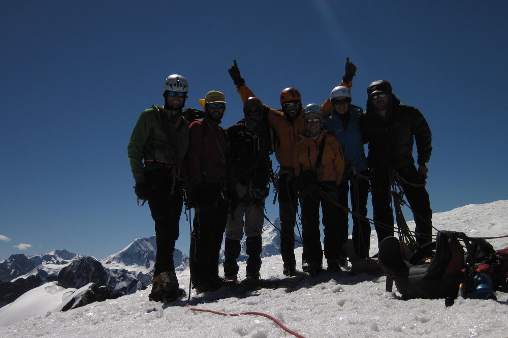
Esa noche comimos un mega guiso en el refugio, gracias al equipo de cocineros. Eramos un grupo grande, diez durante el día y nueve a la noche (Lucas se tuvo que ir), ¡imposible aburrirse!
 |
| El equipo alimentándose, de izquierda a derecha:Cabe, Lucas, Santi, el Vasco, Marín, Nuria, me, Pancho, la Peti y Anibal (Foto por el Cabe) The team feeding up, from left to right: Cabe, Lucas, Santi, el Vasco, Marín, Nuria, me, Pancho, la Peti and Anibal (Photo by el Cabe) |
Al otro día escalamos algunas rutas más, y a la tarde volvimos para Huaraz. Estos dos días realmente los disfruté, no se si fue el cambio de actividad, que la aclimatación estaba empezando a funcionar, o la compañía de los amigos, cuestión que me estaba sintiendo mucho mejor. También se me fue de la cabeza la idea de ir a la playa y ya me estaba poniendo ansioso por nuestra próxima salida a la montaña.
 |
| Escalando en Hatun. Rock climbing in Hatun. |
Rock climbing in Hatun Machay
The
next morning, we where heading out to Hatun Machay, a refuge somewhere
southwest, in the Cordillera Negra. The place is inside natives lands, a
refuge was build there some years ago, which is concessioned. You can
also camp near the refuge and use the kitchen and bathrooms. You are
charged a fee, even if you go for the day. The place is like a forest of
stones, rock peaks from about 30 to 80 m height raising from the
mountain slopes. There are also some archaeological sites to visit.
After
a couple of hours of traveling, we got there. We put up the tent and
headed to the rocks. In the approach walk, I was feeling better, despite
the fact that this site is about 4300 m.a.s.l.. Rock climbing felt so
good from the first moment, I had forgotten how much I liked it!.
That
night we ate a big "guiso" inside the refuge, thanks to the cooking
team. We were a big group, ten during the day, and nine at diner (Lucas
had to left), impossible to get bored!
The
next day we went for some more routes, and in the evening we returned
to Huaraz. These two days were really enjoyable for me, I'm not sure if
it was the change of activity, the acclimatization that was catching up,
or the company of so many friends, but I was feeling definitely better.
I also forgot about going to the beach, and was a little bit anxious to
get to our next mountain destination.
Yanamarey y el tráfico en Perú
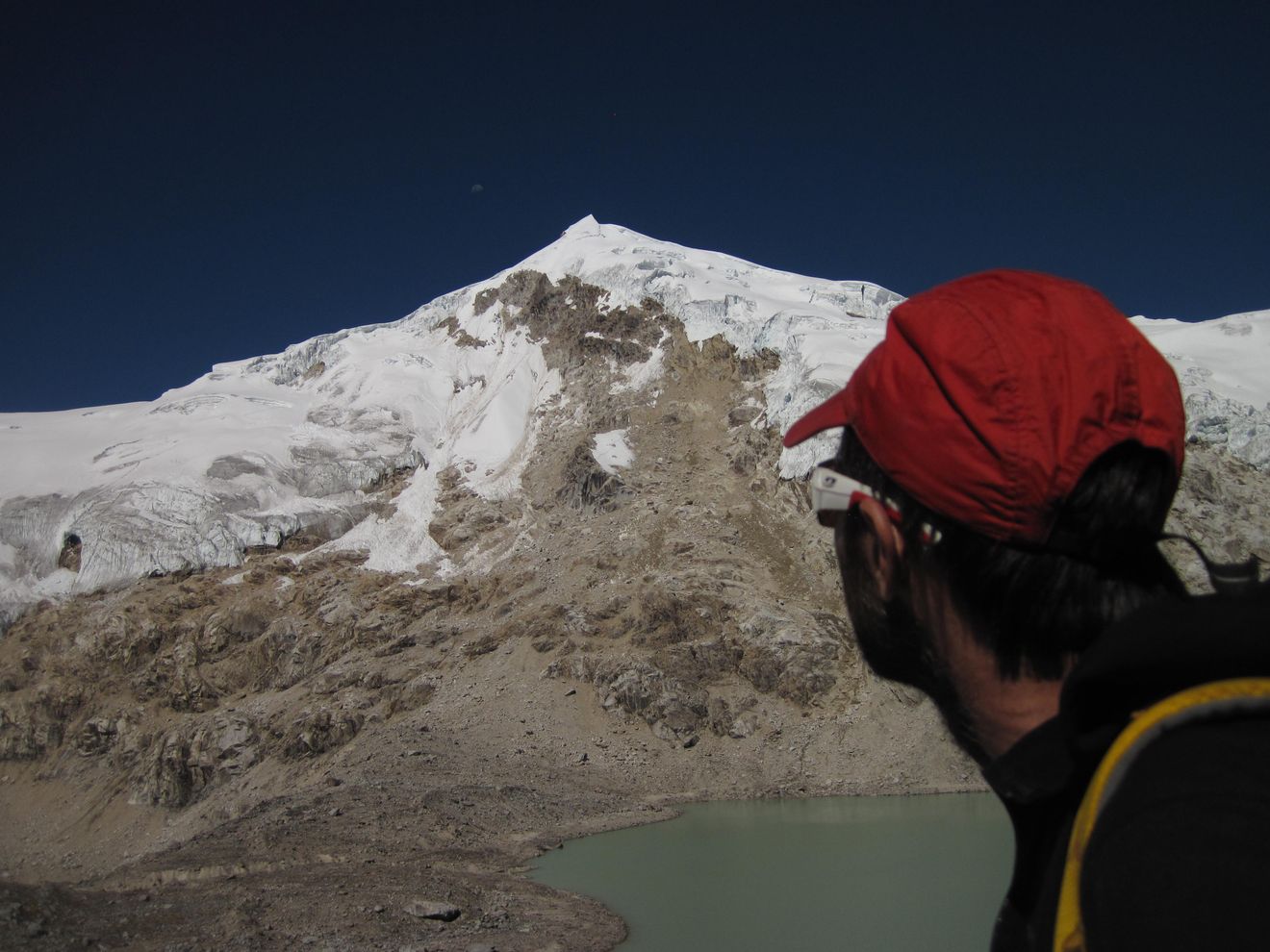
Después de escalar en Hatun, el plan era que todos (un grupo de nueve) fuéramos al cerro Copa, de unos 6200 m.s.n.m., al norte de Huaraz. Para esta salida necesitábamos al menos unos cuatro días de buen clima, pero el pronóstico no era tan bueno: Teníamos los próximos dos días de buen clima y después un poco de nubes y precipitación. Así que luego de debatir un rato (toda la tarde del Domingo, en realidad) decidimos ir hacia Yanamery, un cerro de unos 5200 m.s.n.m. al sudeste de Huaraz. Teníamos dos opciones: Caminar un valle (unos 12 km) desde la laguna Querococha, o seguir un poco más por la ruta hasta un paso con un túnel. Desde ahí había que subir a un filo (a unos 4900 m.s.n.m.), bajar para alcanzar el glaciar y después caminar hasta la cumbre del Yanamarey.
 |
| Yanamarey, la quebrada del mismo nombre y laguna Querococha. En azul, el camino desde el campamento a la cumbre, la bajada fue por el valle. Yanamarey, the eponymous valley and Querococha lagoon. In blue, the way up to the summit, we went down trough the valley. |
Eramos un grupo grande, así que la logística no fue fácil. Anibal estaba organizando el viaje, ya que tenía muchos contactos por Huaraz y la zona. Nos tomamos un colectivo hasta el pueblo de Catac, donde nos encontramos con nuestro taxista. Nos quería meter a todos juntos (con mochilas y todo) en un solo auto, que tenía ocho asientos (no demasiado grandes), pero Anibal lo convenció para que consiguiera otro auto, así que el viaje estuvo más o menos cómodo.
 |
| Embotellamiento camino al campo base de Yanamarey. Pucaraju de fondo. Traffic jam in the way to Yanamarey's camp site. Pucarajo in the background |
El viaje nos llevó gran parte del día, encontramos un lugar para acampar con la última luz del día, mientras otro grupo miraba el camino para el día siguiente. Comimos algo y nos fuimos a dormir, al otro día al amanecer nos íbamos para arriba. La noche estaba fresca, incluso me tuve que poner las botas dobles para cena. Estábamos a 4500 m.s.n.m.
Teníamos un par de opciones para cruzar el filo que nos dejaría en el valle correcto, elegimos el camino de la derecha derecha (más al este) y salimos para arriba. Esta vez me sentía con más energía que en nuestras salidas anteriores, incluso podía caminar con un paso más o menos normal.
 |
| Subiendo al filo, en busca del valle que nos lleve a Yanamarey. Going up to the ridge, looking for the valley that lead as to Yanamarey. |
Después de dos horas, llegamos al filo, desde donde se veía la cumbre elegida. Parecía que había que bajar bastante para después volver a subir, o hacer una gran travesía a la derecha, que se veía con mucha pendiente, y no se alcanzava a ver su final. Así que elegimos bajar, que no resultó tan fácil, por momentos tuvimos que destrepar, aunque no hizo falta rapelar. Esta vez eramos siete: Martín, el Vasco (Andrés), Santi, el Cabe (Ezequiel), Nuria, la Peti (Flor) y yo. Anibal y Pancho (Francisco) se habían quedado en el campamento.
Después de encontrarnos todos abajo, seguimos lo que quedaba de la caminata hasta el comienzo del glaciar. Ahí nos pusimos el "traje de glaciar": Botas, grampones, cuerda, arnés, etc. Después de una demostración de uso de grampones por el Vasco, nos encordamos y empezamos a caminar por el glaciar.
 |
| Montándonos al glaciar, al fondo, el valle que lleva a la laguna Querococha. El Pucaraju a la derecha. Stepping up into the glacier, in the back, the valley that leads to Querococha lagoon. Pucaraju to the right. |
Adelante nuestro iba otro grupo, así que las huellas estaban marcadas, la nieve estaba firme, y un poco honda sobre el fina, en una pendiente a sotavento donde se había acumulado algo de nieve durante las últimas nevadas (hacía unas dos semanas).
 |
| Martín, el Vasco y las chicas subiendo la última sección del glaciar. Martín, el Vasco and the girls climbing the last section of the glacier. |
Después de seis horas y media, todos llegamos a la cumbre sin problemas, esta vez me sentía mejor que en nuestras salidas anteriores. Esta fue mi primer cumbre en Perú, después de casi dos semanas y dos intentos de cumbre. Pero la mejor parte era estar rodeados de tantos amigos, compartiendo la cumbre y los días con ellos.
 |
| Cumbre! Summit! |
 |
| Martín y yo en la cumbre, en realidad había dos "cumbres" con práctimante la misma altura. (Foto por Flor) Martín and I in the summit, in fact there were two "summits" with virtually the same height. (Photo by Flor) |
Después de disfrutar de la cumbre un rato, empezamos a mirar el camino de vuelta. Nadie tenía ganas de subir la pendiente que habíamos bajado para llegar al pie del glaciar, así que había dos opciones: Subir por una pendiente un poco más abajo del valle, por el otro paso que habíamos visto (unos 200 m de subida, camino que nos sugirió la otra cordada que cruzamos), o caminar hasta el fondo del valle hasta la laguna Querococha, donde tendríamos que tomar un taxi para volver al campamento. Yo voté por la primera opción, pero nadie tenía ganas de subir, así que decidimos bajar por el vallo, ¿cuán largo podía ser?
 |
| Para abajo nomás, hasta el fondo del valle fue la ruta elegida. Time to go down, to the end of the valley was the chosen route. |
Antes de empezar la bajada, el Vasco le mandó un mensaje a Anibal con el teléfono satelital, contándole sobre nuestro plan, así podía ir a esperarnos en la laguna.
El valle resultó ser un poco más largo de lo previsto (la laguna no aparecía nunca!), así que nos llevó un poco más de tiempo que lo esperado. Martín y el Vasco y iban adelante, buscando el camino, Santi y el Cabe iban al medio y yo estaba al fondo con las chicas, sacando algunas fotos y mirando por última vez la pendiente que habíamos decidido no subir. Para ese entonces ya estaba extrañando mis zapatillas, que había dejado en el campamento suponiendo que iba a hacer frío, como la noche anterior.
Después de un rato, empezamos a separarnos y en un momento me encontré con Martín, que había perdido de vista al Vasco. Había un solo camino (para abajo), así que seguimos caminando. Casi al atardecer llegamos a la laguna, y ahí me acordé que había que darle la vuelta, la ruta estaba en la otra punta, así que mejor saquemos las linternas.
 |
| Por fin la laguna, ya estamos... Ah no, la ruta está del otro lado... The lagoon, at last, we are there... Not yet, the road is in the other end... |
Finalmente, llegamos a la ruta, qué alivio sacarme las botas dobles! (igual, dentro de todo no estuvieron tan mal, considerando que caminamos unos 16 km). Se suponía que Anibal y Pancho iban a estar ahí esperándonos, pero no los encontramos. Después de no más de cinco minutos parados al costado de la ruta, nuestro taxista paró en la banquina. Esto nos pareció extraño, ya que venía solo, y tuvimos suerte de que nos reconociera (después nos contó que le había parecido raro ver dos linternas, así que pensó que podíamos ser nosotros). Resulta que Anibal nunca había recibido el mensaje, así que estuvo todo el día esperándonos en el campamento, un tanto ansioso; incluso subió un poco hasta el filo a ver si nos veía. El taxista estaba esperando ahí, porque la idea era que siguiéramos viaje hacia Chavín. Cuando se hizo de noche, Anibal le dijo al taxista que se fuera y volviera al otro día, y ahí fue cuando, totalmente de casualidad, nos vio al costado de la ruta, de camino a su casa.
Entonces ahora, ¿qué hacemos? Decidimos que yo iba a esperar a los otros mientras Martín subía de vuelta al campamento para juntarse con los muchachos y decidir qué hacer. Después de un rato empecé a ver luces en la otra punta de la laguna, y después de unos minutos los chicos llegaron. Para ese entonces, ya estaba haciendo frío, no habíamos agarrado mucho abrigo porque se suponía que íbamos a volver de día. Una hora despúes, más o menos, volvió el taxi: Los muchachos habían cargado todo, volvíamos para Huaraz.
 |
| Ya casi estamos: El Vasco, Santi, el Cabe, Nuria y Flor del otro lado de la laguna. ¿Alguien reconoce alguna constelación? (no pude encontrar la cruz del sur en todo el viaje) Almost there: El Vasco, Santi, el Cabe, Nuria and Flor in the other side of the lagoon. Someone knows about constellations? (I wasn't able to find he south cross in the entire trip) |
Ahí fue cuando caí en la cuenta de que nosotros, y todas las mochilas, teníamos que entrar en el auto, "esto va a doler", de nuevo... Nuestro amigo taxista apiló las mochilas arriba del techo, y ató todo con unos cordines. Cuestión que había 8 asientos para 10 pesonas, la cuenta era fácil: dos adelante, cuatro en el medio y cuatro atrás. El viaje duró algo así como una hora y media. Estoy seguro que este fue el viaje más incómodo de toda mi vida, sin embargo estaba contento de volver al pueblo y no tener que pasar la noche a la intemperie, sin bolsa de dormir.
Finalmente llegamos a Huaraz, incluido todo el equipaje (realmente un milagro), hora de dormir un poco. Mañana será otro día.
Yanamarey and the traffic in Perú
After
climbing in Hatun, the plan was to go the nine of us to Copa, a 6200 m
high peak north of Huaraz. For this plan, we needed at least four days
of good weather and the forecast wasn't so good: We had the next two
days of good weather, and then some clouds and precipitation. So after a
long debate (which lasted all Sunday) we decided to go to Yanamarey, a
5200 m.a.s.l. peak south east of Huaraz. There were two options:
Walk a long valley (about 12 km) starting in Querococha lagoon, or
continue through the road up to a pass with a tunnel. From there, you
need to climb up a ridge (about 4900 m.a.s.l.), then go down to reach
the glacier, and finally walk up to Yanamarey's summit.
We
were a big group, so the logistic wasn't easy. Anibal was organizing
the trip, since he had a lot of contacts in Huaraz and nearby. We took a
local bus to Catac, where we would met our taxi driver. He was hopping
to get all of us (with packs and all) inside his car, which had eight
(not too big) seats, but Anibal convinced him to get another car, so we
were more or less comfortable.
The
trip took some time, and we found a camping spot just with the last
light of the sun, while some others were spotting the route for the next
day. We eat something and went to sleep, tomorrow at dawn we'll start
walking. The night was cold, I had to wear my double boots just for
eating. We were at about 4500 m.a.s.l.
There
were a couple of options to get through the ridge who would put us in
the right valley, we took the one at the right (eastern one) and headed
up. This time I felt with more energy than the previous treks, I could
also walk with a not-so-crawling pace. After two hours, we got to the
ridge, were we could see our target summit. It looked that we had to go
down, and then up again, or do a big traverse, but the ridge was steep
and we couldn't see it completely. So we opted to go down, which wasn't
easy, we had to downclimb some short sections, but we didn't needed any
rappel. We were seven this time: Martín, el Vasco (Andrés), Santi, el
Cabe (Ezequiel), Nuria, la Peti (Flor) and me. Anibal and Pancho
(Francisco) were staying at the camp.
After
grouping up at the end of the descent, we started the remaining
approach to the glacier. There we dressed as "glacier travelers": Boots,
crampons, rope, harnesses, and so on. After some crampon use
demonstration by el Vasco, we roped up and started the walk up the
glacier. Another team was ahead of us, so the trail was marked, the snow
was firm and just a little bit deep at the end, in a leeward slope were
some new snow had accumulated in the last storms (about two weeks ago).
After
six and a half hours we all got to the top with no trouble, I was
feeling definitely better than the last time. This was my first Peruvian
summit, after almost two weeks and two summits attempts. But the best
part was to be surrounded by so many friends at the summit, and shearing
these days with them.
In the summit everything was good, but then we started to analyze the way back. No one wanted to climb the slope we had descended in the way to the glacier base, so we had two options: Going up the slope a little bit down the valley, through the other pass we had seen (about 200 m of climb, this was suggested by the other party we met), or walking all the way back to the Querocoha lagoon were we should get a taxi to get back to camp, high in the road. I voted for the first option, but no one wanted to go up again, so we decided to go down through the valley, how long it could be?
In the summit everything was good, but then we started to analyze the way back. No one wanted to climb the slope we had descended in the way to the glacier base, so we had two options: Going up the slope a little bit down the valley, through the other pass we had seen (about 200 m of climb, this was suggested by the other party we met), or walking all the way back to the Querocoha lagoon were we should get a taxi to get back to camp, high in the road. I voted for the first option, but no one wanted to go up again, so we decided to go down through the valley, how long it could be?
Before beginning the descent, el Vasco send a message to Anibal through a
satphone, telling him about our decision, so they could be waiting for
us in the lagoon.
The
valley turned out a little bit longer than our calculations (the lagoon
wasn't showing up!), so it took us more time than expected. Martín and
el Vasco where at the front, looking for the trail, Santi and el Cabe
where in the middle and I was in the back with the girls, taking some
pictures and looking again the ridge we had decided not to climb. At
that point, I was starting to miss my running shoes, which I had left
in camp supposing that the temperatures would be rather cold all day.
After
some time, we started to spread out and in one moment I found Martín,
who had lost sight of el Vasco. There was only one direction, so we
continued down. Almost at dusk, we got to the lagoon, and there I
remembered that the road was in the other side of the lagoon, so let's
look for some headlamps. Finally, we got at the road, what a relief to
take out my double boots (nevertheless, they were not so bad, since we
had walked about 16 km). It was supposed that Anibal and Pancho would be
there, waiting for us, but there was no sign of them. At some point,
after no more than five minutes standing beside the road, our taxi
driver stopped. This was kind of confusing, since he was alone, and we
where lucky he recognized us in the dark (then he told us he saw two
headlamps, and that looked strange to him, so he thought it could be
us). It turned out that Anibal never got the message, so he had been in
camp all day anxiously waiting for us, even he got up a couple of times
to the ridge to try to meet us. The taxi driver was waiting there, since
we were supposed to continue our trip to the town of Chavín.
When it got dark, Anibal told the taxi driver to go home and came back
the next day, and, completely by chance, he spotted us in his way back
home.
So
now, what to do? We decided that I would wait the others there, and
Martín would go up to the camp, to talk to the guys ans see what to do.
After some time, I start to see some lights at the other side of the
lagoon, and some minutes latter they arrived. At this point, it was
getting colder, we hadn't picked up too much clothes because we were
supposed to get back to camp before dark. Some minutes latter, the taxi
arrived again: The guys had packed up everything, we were heading back
to Huaraz.
Here
was wen I realized that we, and all the load, should got inside the
car, "this is going to hurt", again... Our friend piled up our backpacks
in the car's roof, and tied everything with some cords. So, we had 8
seats for 10 people, the math was easy: two in the front, four in the
middle, and four in the back. The trip lasted about an hour and a half.
I'm almost sure that was the more uncomfortable trip of all my life,
nevertheless I was glad to be heading to town and not be there waiting
for the night to pass, without a sleeping bag.
In
the end, we all got to Huaraz, including all of our gear (really a
miracle, in my view), let's go for some sleep again. Tomorrow will be
another day.
Se acerca el final, valle de Ishinca
Después de dormir un poco, estábamos de vuelta mirando el mapa, buscando nuestro próximo destino. En el hostel nos encontramos con Maxi y Laura, y también Jochi (Leando) y Ro (Rocío), dos parejas de cordobeces. Estaban recién llegados de Pisco y Yanapaqcha. Jochi y Ro se iban al otro día para la quebrada de Ishinca. Maxi estaba muy motivado con escalar lo que sea. Laura no se sentía muy bien, así que Maxi estaba buscando compañeros de escalada. En un momento empezaron a salir de su boca nombres de cumbres, valles y rutas de escalada a una velocidad que yo no podía procesar, pero no se podía decir que no había opciones.
 |
| Con los cordobeces en el hostel, de izquierda a derecha: Ro, Jochi, Maxi, yo y Martín. (Foto por Laura) With the cordobeces at the hostel, from left to right: Ro, Jochi, Maxi, yo y Martín. (Photo by Laura) |
Con Martín estábamos planeando ir a algún valle por el resto del viaje, unas seis o siete noches. Cabe y Santi estaban más o menos en la misma situación, pero con un día menos. La idea era ir a un lugar donde se pudieran intentar varias cumbres y tratar de escalar alguna de ellas según las condiciones del clima, el tiempo disponible, la motivación y cómo nos sintiéramos.
Teníamos algunas opciones: La quebrada de Ishinca, el refugio Perú, Chopicalqui... A mi me venía bien cualquier opción, porque no conocía ninguna, pero Martín ya había estado en los tres lugares. Finalmente partimos al valle de Ishinca con Maxi y Laura, Jochi y Ro ya estaban ahí. Nuestro principal objetivo era el Ranrapalca, por la ruta normal o por la cara noroeste. Desde el mismo valle también se podían escalar Ishinca, Tocllaraju y Urus, el Ocshapalca estaba cerca también. La idea era subir primero al Ishinca para ver el Ranrapalca más de cerca, y ahí decidir qué ruta intentar.
 |
| Valle de Ishinca. Ishinca Valley. |
 |
| Llegando al campo base de Ishinca, Toclaraju al fondo a la izquierda. Near Ishinca base camp, Toclaraju at the bottom. |
Así que después de un par de días de descanso y preparativos, salimos para el valle de Ishinca. La aproximación nos llevó unas tres horas y media. El plan era subir al Ishinca al otro día. Después de un rato descansando en el campamento, nos encontramos con Ro y Jochi, que venían del Ishinca. Hay dos rutas clásicas en Ishinca, una por la derecha y otra por la izquierda. Ellos habían subido más o menos por el medio, con un poco de escalada en roca antes de montarse al glaciar para llegar a la cumbre. Así que decidimos hacer un intento por esa vía. Maxi y Martín estaban bastante confiados, pero yo no tenía idea cómo era eso de escalar a 5000 m de altura.
 |
| Ishinca al atardecer, desde el refugio Longoni. Las rutas normales van por los filos de la derecha e izquierda, la ruta directa va por las rocas del medio. Ishinca at sunset, from Longoni hut. The normal routes goes through the right and left ridges, the direct route goes through the central rocks. |
La mañana siguiente empezamos a caminar a eso de las seis de la mañana, justo al amanecer. Estábamos acampando a unos 4400 m.s.n.m., y el Ishinca tiene unos 5500 m.s.n.m. Después de un par de horas pasamos cerca del refugio Longoni, a unos 5000 m.s.n.m. Ahí encaramos hacia el comienzo de la escalada, que resultó más una caminata que escalada en si. Sin embargo, había dos secciones donde había que concentrarse.
 |
| Al comienzo de la vía, mejor nos ponemos el arnés, por si acaso... At the start of the route, let's put on the harness, just in case... |
Maxi iba adelante, escalando sin cuerda, y en un momento dijo "mejor saquemos la cuerda acá". Así que armó una reunión y Martín empezó a escalar. Después de unos dos metros, a Martín se le rompió una toma de la mano, buena idea la de sacar la cuerda... Después me tocó a mi y nos encontramos en la reunión. El largo era corto, unos ocho o diez metros. Ahora quedaba una travesía corta a la izquierda, arriba de unas piedras congeladas, y después ya estábamos sobre el glaciar. Martín fue de primero sin problemas.
 |
| Maxi en el crux, Martín escalando. Maxi at the crux, Martín climbing. |
 |
| Unos pasos más antes de llegar a la nieve. (Foto por Martín) One more steps before the snow slope. (Photo by Martín) |
Desde ahí seguimos para arriba por el glaciar, encordados. Pensándolo después, quizás no fue muy buena idea ir encordados, porque no estábamos poniendo seguros, no había grietas a la vista y la pendiente no era despreciable (unos 45 o 50 grados), así que si uno se caía, iba a ser difícil frenarlo. De todas formas, la nieve estaba blanda, así que una caída era bastante improbable.
 |
| Con Martín, al comienzo de la nieve, Toclaraju de fondo. (Foto por Martín) With Martín at the start of the snow slope, Toclaraju in the background. (Photo by Martín) |
 |
| Maxi y yo escalando hacia la cumbre, un poco de paciencia por favor... (Foto por Martín) Maxi and me climbing to the top, just a little patience please... (Photo by Martín) |
 |
| Maxi y Martín en la cumbre, Ranrapalca de fondo. Maxi and Martín at the summit, Ranrapalca at the bottom. |
 |
| Todo el equipo en la cumbre, el pico más grande a la derecha es el Pucaranra. (Foto por Martín) All the team at the top, Pucaranra is the biggest peak to the right. (Photo by Martín) |
A eso del medio día llegamos a la cumbre, la vista desde ahí arriba era realmente muy buena, lleno de montañas para escalar, y tan poco tiempo! Desde ahí se veían las dos rutas del Ranrapalca que queríamos escalar. Jochi había dicho que la ruta de la cara noroeste tenía mucha caída de piedras, así que fuimos hacia la pared a mirar un poco más de cerca. En realidad, las piedras caían más a la izquierda de la ruta, la cara noroeste se veía en buenas condiciones, casi toda cubierta de nieve, con tres bandas de roca. La dificultad de la ruta debía estar en cruzar esas bandas de roca. Martín y Maxi subieron un poco más para mirar el pie de vía desde más cerca, yo hice un intento, pero ya me estaba sintiendo cansado de la escalada y probablemente de la altura, así que los esperé ahí, "les creo muchachos"...
 |
| Vista panorámica desde la cumbre de Ishinca. Los picos más altos de izquierda a derecha: Toclaraju, Palcaraju, Pucaranra y Huantsán Panoramic view from Ishinca summit. The highest peaks from left to right: Toclaraju, Palcaraju, Pucaranra and Huantsán |
 |
| Ranrapalca: La ruta normal va por la derecha de la pared de piedra principal, la cara noroeste es el nevé a la derecha de las piedras. Ocshapalca en el fondo, a la derecha. Ranrapalca: The normal route goes to the left of the main rock face, the northwest face is the snow slope to the right of the rocks. Ochsapalca in the background, to the right. |
Después de mirar más de cerca las vías, nos decidimos por la cara noroeste. El plan era descansar un par de días y después volver, así que dejamos algo de equipo abajo de unas piedras y emprendimos el regreso. De vuelta en el campo base, nos encontramos con los muchachos, comimos algo y nos fuimos a dormir. Me sentía cansado del día, pero mucho mejor que nuestros intentos anteriores.
 |
| ¿Qué tal esa vía Tincho? How was that route Tincho? |
 |
| Topo de la vía directa al Ishinca. (Topo por Martín) Topo of the Ishinca direct route. (Topo by Martín) |
 |
| Descansando en el campo base, con Martín, Ro, Jochi, Maxi y Laura (de izquierda a derecha). Resting and eating in base camp, with Martín, Ro, Jochi, Maxi and Laura (from left to right). |
El Ranrapalca tiene unos 6100 m.s.n.m., Maxi quería empezar la escalada desde el campo base, porque eran solo unas tres horas de aproximación hasta el pie de vía. Pero Martín decía que 1800 m de desnivel en un día era mucho. Al final, Martín tendría razón. Así que decidimos subir al refugio Longoni, a unos 5000 m.s.n.m., de esta forma el día de cumbre serían unos 1100 m de desnivel. La caminata hasta el refugio fue sin problemas, llegamos con tiempo suficiente para comer, tomar algo y dormir.
 |
| Mirando la ruta elegida, desde el refugio Longoni. Looking at our intended route, from Longoni hut. |
Al otro día empezamos a caminar a las 4 am. Para el amanecer ya estábamos al pie de vía, después de pasar a buscar el equipo. La ruta era una pendiente de nieve con una inclinación que se incrementaba desde los 40 hasta los 60 grados. La nieve estaba cubierta con penitentes, que hacían la escalada un tanto incómoda. Sin embargo, nos estábamos moviendo a buen ritmo, y en un rato llegamos a la primer banda de roca. Maxi empezó a escalar en solo, buscando el camino. Estaba por meterse en un diedro cuando Martín le marcó un camino más fácil a la derecha. Me parece que a Maxi le gusta escalar en roca...
 |
| Llegando al pie de vía, al amanecer. Getting to the base of the climb, at dawn. |
 |
| Si, hora de escalar, no queda otra... And yes, it's climbing time, no other way around... |
 |
| ¿Cómo viene esa escalada?. (Foto por Martín) How's that climbing going?. (Photo by Martín) |
Pasando la banda de roca, volvimos a la pendiente de nieve, había algo de hielo duro y un pequeño serac, que pasamos por la izquierda. Escalar el hielo con los penitentes requirió de un poco de imaginación. A esta altura, más o menos venía siguiendo el paso de Maxi y Martín, pero claramente era el más lento, y estaba empezando a sentir los efectos de la altura.
 |
| Saliendo de la primer banda de roca. Going up after the first rock band. |
Me encontré de vuelta con los muchachos en la segunda banda de rocas. Maxi había escalado en solo unos seis metros, donde había armado una reunión. Ahora le tocó el turno a Martín de primerear el resto del largo. Yo los seguí de top. Al final había unos pasos interesantes, incluyendo un poco de hielo arriba de la roca, todo con las botas dobles puestas. Esta era mi tercera vez escalando con botas rígidas, me tuve que concentrar bastante en los movimientos.
 |
| ¡Voy! Climbing! |
 |
| "Hay un pasito ahí", Martín saliendo de la segnda banda de rocas. "Be careful there", Martín at the top of the second rock band. |
Después de la segunda banda de rocas, venía otra sección de nieve, con los mismos penitentes, pero con la diferencia de que esta rampa parecía interminable. A esta altura ya era claro que no podía seguir el ritmo de los muchachos. Así que traté de decirles que siguieran, que yo los esperaba acá. No quería retrasarlos, y tampoco estaba seguro de poder seguir subiendo mucho más y que todavía me quedaran energías para bajar. El problema era que no me escuchaban. Después de un rato vi que pararon a esperarme, ahí estábamos a unos 6000 m.s.n.m., mi punto más alto hasta el momento. El día estaba bueno, soleado y casi sin viento, todavía con unas seis horas de sol, así que decidimos que ellos seguirían para arriba y yo los esperaría ahí. Para ese entonces, Maxi ya estaba escalando la tercer banda de roca.
 |
| Y otra rampa de nieve más, llena de penitenes. And yet another snow slope, full of penitents. |
Así que me busqué una piedra donde sentarme a descansar, tomar y comer algo, pero resultó que a mi estómago no le gustaba mucho digerir la comida, así que decidí bajar un poco. Destrepé unos 200 m, cerca de la parte superior de la segunda banda de rocas, ahí encontré una piedra casi horizontal, así que me dispuse a dormir la siesta. Después de un rato hasta pude comer sin problemas.
Cuestión que me senté ahí por unas horas, y ahí fue cuando me di cuenta que no tenía forma de bajar de ahí sin Martín y Maxi, que tenían las dos cuerdas. Desescalar la segunda banda de roca estaba fuera de mis habilidades. Pero estaba confiado en que los muchachos iban a llegar a la cumbre y bajar sin problemas. Según me contaron después, luego de la tercer banda de roca había un poco más de nieve hasta llegar al plató de la cumbre. Ahí se encontraron con nieve en polvo hasta la rodilla, lo que resultó bastante cansador, física y mentalmente. Finalmente llegaron a la cumbre, "un mini Alpamayo" (según Martín), con una cornisa que mejor no acercase mucho.
 |
| Martín en la cumbre del Ranrapalca. De fondo, Toclaraju a la derecha y Huascaran a la izuquierda, entre las nubes. (Foto by Maxi) Martín at Ranrapalca's summit. In the background, Toclaraju to the right and Huasaran to the left, between the clouds. (Photo by Maxi) |
 |
| ¿Cómo estuvo eso Maxi? La cumbre, al fondo, se alcanzan a ver las huellas. (Foto por Martín) How was that Maxi? The summit, in the background, the trail is visible. (Photo by Martín) |
Después de un par de horas, los vi empezando a bajar. Estaban rapelando en lugar de destrepar, lo que me pareció raro, porque les llevaba más tiempo. Pero el sol había ablandado un poco la nieve así que destrepar no estaba tan fácil como un par de horas antes cuando bajé yo.
Nos encontramos de vuelta, y seguimos con los infinitos rapeles hasta la base de la pared, donde llegamos un rato después del atardecer. Ahí nos sacamos las botas y grampones y seguimos caminando hacia el refugio. A esa altura, fue como que todo el cansancio me pegó de golpe. Estaba realmente cansado, incluso tres pasos de subida requerían de mucha concentración.
 |
| Y otro rapel más... Creo que fueron unos diez en total. (Foto por Martín) And yet another rappel... I think they were about ten in total. (Photo by Martín) |
 |
| Martín destrepando, el refugio está a la derecha de la laguna. Martín going down, the hut is right to the lagoon. |
 |
| Me parece que vamos a necesitar las linternas, de nuevo... I think we'll need the headlamps, again... |
La idea original era seguir bajando hasta el campo base, donde Laura nos estaba esperando, pero yo tenía bastante claro que iba a dormir en el refugio. Cuando casi estaba llegando al refugio, me di cuenta que los últimos 500 m eran en subida. Esa "escalada" final fue realmente cansadora...
Así que de vuelta en el refugio, ¡llegamos!, hora de festejar, comer y dormir... Si no fuera por ese detalle... No tenemos agua, ¿quién va a buscar un poco? Creo que habría preferido irme a dormir sin tomar nada. Al final Matín, en un acto de heroísmo, se ofreció a buscar un poco, no sin antes perderse en el camino. Para terminar el día largo, nos tomamos unas sopas y nos fuimos a dormir. Ya era medianoche.
 |
| La via de la cara noroeste en el Ranrapalca, vista desde el Toclaraju. (Foto por Jochi, topo por Martín) The northwest route on Ranrapalca, as seen from Toclaraju. (Photo by Jochi, topo by Martín) |
A la mañana siguiente, cargamos todo en la mochila, limpiamos un poco el refugio, y seguimos para abajo hacia el campo base. Ahí nos encontramos con Laura que nos estaba esperando un tanto ansiosa, incluso el día anterior había subido un poco a ver si nos veía bajar. Nuevamente, nuestros cálculos de tiempos había sido un tanto optimistas. Nos tomamos el día de descanso para (adivinen) comer, dormir e hidratar.
Luego hicimos algunos cálculos y nos dimos cuenta que nos quedaban tres noches en Perú. La última íbamos a estar arriba del colectivo viajando a Lima. Así que en realidad nos quedaban dos noches. Podían ser dos noches en la montaña, o podíamos pasar una noche en Huaraz para organizar el equipaje, bañarnos, comprar algunos regalos y esas cosas que uno hace en la ciudad.
Así que ¿con qué seguimos?... La ruta directa al Tocllaraju se veía en muy buenas condiciones. Jochi y Ro habían subido por la ruta normal y decían que las condiciones estaban ideales. La idea era realmente tentadora. Pero teníamos solo un día de descanso, después tendríamos que intentar el Tocllaraju en el día, desde el campo base (unos 1600 m de desnivel), y a la mañana siguiente guardar todo todo, bajar a Huaraz, conseguir pasaje en colectivo y viajar a Lima. Parecía demasiado apretado el cronograma, sobre todo con un solo día de descanso, así que decidimos bajar al otro día, así no teníamos que andar corriendo para llegar al avión en Lima.
En algún momento de la tarde alguien dijo "acá esta el Urus, se puede subir y bajar en unas cinco horas", así que hice las cuentas: Salimos a eso de las nueve o diez de la mañana, así que si arrancamos a las tres estamos de vuelta justo a tiempo para encontrarnos con el arriero y los burros. Así que le comenté la idea a los otros. Todos habían subido al Urus, Martín incluso dos veces, así que nadie estaba muy entusiasmado con la idea.
 | |
| Urus entre las nubes, a la derecha. Abajo se ve el refugio y la zona de acampe. La ruta normal va por la arista de piedras, después se sube a la rampa de nieve a la derecha del glaciar y finalmente travesía por el filo hacia la izquierda hasta la cumbre. Urus between the clouds, to the right. The hut can be seen in the valley, and also the camping site. The normal route climbs the rocky ridge, then it gets into the snow slopes right to the glacier and finally traverses the ridge to the left to get to the top. |
El camino que sube al Urus arranca cerca del campo base, y se pone empinado desde el principio (a unos diez minutos de empezar, literalmente), después hay una pendiente de nieve, sin glaciares, y una caminata por un filo hasta llegar a la cumbre, a unos 5300 m.s.n.m. El plan parecía sencillo y me estaba sintiendo bien, así que no me pude resistir. A eso de las tres de la mañana estaba caminando solo por la noche, buscando el comienzo del camino. La caminata fue sin problemas, y llegué a la cumbre a eso de las seis y cuarto de la mañana, justo para el amanecer. La vista es realmente increíble, se veía de cerca el Tocllaraju, y unos cuantos picos hacia el norte y el este. La luz no era muy buena para sacar fotos, y después la cámara empezó a fallar. Ahí fue cuando miré el reloj y me di cuenta que era el día más frío hasta el momento, unos siete grados bajo cero. Empecé a bajar, después de mirar cómo el sol pintaba en tonos de rojo la cara norte del Ranrapalca. Desde ahí se veía también el Ocshapalca, un pico entre Ranrapalca y Vallunaraju. Maxi había dicho de intentar una vía ahí, se veía bien, pero quedará para el próximo viaje.
 |
| Cumbre del Urus, al amanecer. Urus's summit, at dawn. |
 |
| Ranrapalca y Ocshapalca recibiendo las primeras luces del día. Ranrapalca and Ocshapalca getting the first daylights. |
A eso de las 8 am estaba de vuelta en el campamento. Todos estaban durmiendo, ya que el campamento todavía estaba a la sombra, así que me metí de vuelta en la bolsa para tratar de dormir un poco. Una hora más tarde, el sol empezó a calentar las carpas, así que hora de levantarse y guardar las cosas. Despúes de un rato llegó el arriero con los burros, cargamos todo y empezamos a bajar.
La bajada del valle de Ishinca se me hizo más larga que lo esperado, quizás en la subida estaba un tanto ansioso, y seguro estaba más descansado. Sin embargo, llegamos a tiempo al final del camino, para encontrarnos con nuestros taxistas.
En el viaje de vuelta, por caminos de ripio, tuve la experiencia más aterradora de todo el viaje: Nuestro taxi se quedó sin frenos, al comienzo de una leve pendiente (para abajo), la caja de cambios no ayudaba mucho a frenar, tampoco el freno de mano. Así que en ese momento el taxista dijo "Chino, vayan bajando" (Chino era otro peruano que estaba en el taxi, por alguna extraña razón), así que todos empezaron a bajarse del taxi en movimiento, menos yo que estaba en el medio del asiento de atrás. Finalmente el taxista frenó el auto, chocando la rueda delantera derecha contra una pila de tierra y piedras al costado del camino. Ahí me bajé y juré no volver a subir a ese taxi.
Los taxistas decían que se habían sobrecalentado los frenos, por eso que no andaban, así que subieron un poco por el camino a buscar un arroyo para enfriar los frenos. Dijeron que esto arreglaría el problema. Yo era un poco escéptico al respecto.
Después de un rato volvieron los taxis, nos subimos de vuelta (yo me tiré de cabeza adentro del otro taxi) y milagrosamente llegamos a Huaraz en un solo pedazo. Parece que así funciona la mecánica en Perú...
The end is near, Ishinca valley:
After
some sleeping, we where looking at the map again, searching for our
next destination. Back in the hostel we met whit Maxi and Laura, and
also Jochi (Leandro) and Ro (Rocío), two Argentinean couples from
Cordoba. They were just back from Pisco and Yanapaqcha. Jochi and Ro
where leaving the next day to Ishinca valley. Maxi was really motivated
to climb almost anything, and Laura wasn't feeling very good, so he was
looking for climbing partners. Names of peaks, valleys, climbing routes
and places where flowing from his mouth at a speed I couldn't process,
but you couldn't say there where no options.
Martín
and I where planing to go into a valley for the rest of the trip, about
six or seven nights. Cabe and Santi where more or less in the same
situation, but with one day less. The idea was to go to some place where
we can have two or three summits around, and try to climb them
depending on the weather, available time, motivation, and how we felt.
There
where some options: Ishinca valley, Perú refuge, Chopicalqui... I was
happy with anyone, since I haven't been there, but Martín had been in
all of that places. Finally we decided to join the cordobeces, and we
headed to Ishinca valley, with Martín, Maxi, Laura; Jochi and Ro were
already there. Our main objective was Ranrapalca, through the normal
rout or through the northwest face. Ishinca, Tocllaraju and Urus where
also accessible from this valley, and Ocshapalca was nearby. The idea
was to climb Ishinca first, to have a look at Ranrapalca, and then
decide what route to follow.
So
after two days of rest and preparations, we headed to Ishinca valley.
The approach took us about three and a half hours. The next day we where
planing to climb Ishinca. After some time some time relaxing in the
camp, we met with Ro and Jochi, who were coming down from Ishinca. There
are two classic routes to Ishinca, one through the right and the other
through the left ridge. They have climbed it more or less through the
middle, with some rock scrambling before stepping into the glacier. They
suggest us to climb directly up through the rock, almost all the way
up, with the last meters of snow and ice. We decided to give it a try.
Maxi and Martín were really confident, but I had no idea how rock
climbing would feel like above 5000 m.
The
next morning, we started to walk about six am, just at dawn. We were
camping at about 4400 m.a.s.l., and Ishinca is about 5500 m.a.s.l. After
a couple of hours of walking we passed by the Longoni refuge, at about
5000 m.a.s.l. There we headed to the base of the climb, which it
resulted to be more a scrambling than a climbing. Nevertheless, there
were two sections which required concentration. Maxi was going firs,
free soloing all the way up, and after a couple of concentrated moves he
said "OK, I think we may take the rope out". He made an anchor, we rope
up and Martín started to follow him. After about two meters of
climbing, a handhold broke apart, good idea to get that rope out... I
followed them and we met at the belay. The pitch was short, about eight
or ten meters. Now we had a short traverse to the left, above some
frozen rocks, and there we could get on top of the snow slope. Martín
led it with no problem. There we continue up the glacier, roped up. In
hindsight, it may had been better to climb unroped, because we were
putting no anchors, there were no visible crevasses, and the slope was
quite steep (about 45 or 50 degrees), so if one felt, it would have been
difficult to stop it. Nevertheless, the snow was soft, so a fall was
rather improbable.
About
midday we stood on the top, the view from there was really good, just
so many mountains to climb, and so little time! From there we could see
both routes on Ranrapalca we were hoping to climb. Both of them looked
in good condition. Jochi said that in the rout we where looking was a
lot of rock fall, so we headed that way to take a closer look. In fact
the rocks where coming down left to the rout, the northwest face looked
in good conditions, almost covered with snow, with three patches of
rock. The crux may laid there. Martín and Maxi climbed to the beginning
of the route to see how it looked, I made an attempt, but was starting
to feel tired from the day's effort and the altitude, so I just wait for
them, "I trust your judgment guys"...
After
taking a closer look to the routes, we decided to try the northwest
face of Ranrapalca, the plan was to rest for a day or two and then came
back, so we left some gear beneath a boulder and started our way down.
Back at base camp, we met the other guys, got something to eat and go to
sleep. I was tired from the day, but much better than at the beginning
of the trip.
Ranrapalca
is about 6100 m.a.s.l., Maxi wanted to start walking from base camp,
since the approach to the base of the rout should take us about three
hours. But Martín argued than 1800 m of elevation gain in a day would be
too much. In the end, Marín was right. So we decided to sleep at 5000
m.a.s.l. in Longoni refuge, that way the summit day would have about
1100 m of climb. The trek to the refuge went without problem, we got
there with time to eat, drink and sleep.
The
next morning we started moving about 4 am. At dawn, we met the base of
the climb, after retrieving our stashed gear. The route was a snow slope
with increasing steepness, from about 40 to 60 degrees. The snow was
covered with penitents, which made the climb awkward. Nevertheless we
were moving at a good pace, and we quickly reached the firs rock band.
Maxi jumped up again in the lead, with no rope. He was about to try a
dihedral when Martín pointed to an easier exit to the right. I think
Maxi likes rock climbing...
We
gained the snow slope again, there was some hard ice and a small serac,
which we passed through the left. Climbing the iced penitents required
some creative movements. At that point, I was more or less following the
pace of Martín and Maxi, but I was clearly the slowest one, and was
starting to feel the effects of height.
I
met the guys in the next rock band. Maxi free soloed for about six
meters and build an anchor. Martín followed and took the lead for the
rest of the pitch. Then I followed in top rope. The last part had some
interesting moves, which involved some ice in the rock, all while
wearing double boots. This was my third time rock climbing with hard
boots, I really had to focus on that moves.
After
the second rock band, we had just another section of snow, with the
same penitents, with the difference that this section looked endless. At
this point, it was clear that I could not keep up with the pace. I
wanted to tell the guys to go on, while I waited for them there. I
didn't want to slowed them down, and I wasn't sure I could get much
higher and still have energy to go down. The problem was that they
couldn't hear me. Then I saw the guys waiting for me, and in a big
effort I got with them, we where about 6000 m.a.s.l., my highest point
up to now. The day was quite nice, the sun was shining, almost no wind,
still six hours of sun left, so we decided they would continue up while
I'll wait them there. At that time, Maxi was almost already starting to
climb the last rock band.
I
searched for a rock to sit on it, so I could try to rest, eat and
drink, but it turned out that my stomach didn't liked to process food,
so instead I started to go down. I down climbed about 200 m, near the
top of the second rock band, there I found an almost flat rock, so I
prepared myself for a nap. After some minutes, I was also able to eat
with no problem.
So
I just sat there for a couple of hours. There, I realized that I had no
safe way to go down with out Martín and Maxi, the had the two ropes,
and it was out of my abilities to down climb the second rock band. But I
was confident the guys would came back from the top without problem. As
the guys told me later, the remaining of the route was a short snow
slope which lead to the summit plateau. There they found some knee deep
powder snow, which slowed them down, physically and mentally. Finally
the got to the top, "a mini Alpamayo" (in Martín's words), with a
cornice that better not to get too close.
After
a couple of hours, I saw they coming back. They were rappeling instead
of down climbing, which seemed strange to me, because it was taking more
time. But the sun had softened the snow, so down climbing wasn't so
easy as some hours ago wen I did it.
We
met again, and continue with the endless rappels to the base of the
climb, where we arrived after sunset. There, we took off our crampons
and boots and continued with the walk to the refuge. At that point, it
was like all the tiredness had punched me in one shot. I was really
tired, even three steps upward required a lot of concentration. The
original idea was to continue down to base camp, where Laura was waiting
for us, but it was clear that I was going to sleep in the refuge. When I
was almost in the refuge, I started to notice that the final 500 m were
slightly upward. That final "climb" was really exhausting...
So
once again in the refuge, we made it, time to celebrate, eat and
drink... That small detail... We were out of water, who'll go down to
the river and bring some? I think I would have preferred not to drink
and go directly to sleep. Finally, Martín heroically went down and
brought some watter, not before missing the path one time. At the end of
the long day, we drank some soups and went to sleep. It was near
midnight.
The
next morning, we packed everything up, clean the refuge, and went down
to base camp. There we found Laura who was anxiously waiting for us ,
the previous day she even walk up the trail trying to spot us in the way
down. Again, our time calculations had been too optimistic. We took the
rest of the day to (guess what) rest, eat and drink.We made some calculations, and we realized we had three more nights left in Perú. The last one was going to be inside the bus, traveling to Lima. So we actually had two nights. It could be two nights in the mountain, or we could take one in Huaraz, to pack everything, have a bath, buy some presents and that kind of city stuff.
So, what to do?... The direct route of Tocllaraju was looking in really good conditions. Jochi and Ro had climbed it through the normal route, they said that conditions were rally good. It was really tempting us. But we only had that day for resting, then we should have to attempt Tocllaraju from base camp (about 1600 m of ascent), then walk down the other morning, pack everything, buy a bus ticket, and travel to Lima. The plan looked like too much, more over with only one rest day, so we decided to go down the next morning, so we would not be rushing the bus back to Lima.
In some moment in the afternoon, someone said "Urus is there, you can get up and down in about five hours", so I made the math: We are leaving about 9 or 10 am, so if we start at 3 am we'll be back just in time to meet the burros and the "arriero". So I told the others about the idea. All have gone up Urus, Martín two times, so no one was very excited with the idea.
Urus starts near the base camp, the trail gets steep just at the beginning (about ten minutes of walk, literally), then you have some snow slopes, with no glacier, and a walk though a ridge to the summit, at about 5300 m.a.s.l. Since it looked relatively easy, and I was feeling good, I decided to give it a try. So the next night, about 3 am, I was walking alone through the night, searching for the start of the trail. The trek went without problem, I reached the summit about 6:15 am, just for the sunrise. The view was really good, a closer look to Tocllaraju, and a lot of peaks to the north and east. The light wasn't too good for taking pictures, and then the camera started to show some malfunctioning. Then I looked to my watch and realized that it was the coldest day up to now, about -7 degrees Celsius. After watching the sun painting the north face of Ranrapalca with beautiful orange tones, I started to go down. From there it was also visible Ocshapalca, a peak between Ranrapalca and Vallunaraju. Maxi had made a comment of climbing some route there, it looked good, but that would be in another trip.
About 8 am I was again in the camp. Everybody was sleeping, since base camp was still in the shadow, so I got again into my sleeping bag trying to rest a little bit. About an our later, the sun started to hit the tents, so we started to move and pack the things. Some time later, the burros arrived, the "arriero" stuffed the packs up them and we started the walk down.
The way down from Ishinca base camp was longer than I expected, may be in the way up I was too anxious, and surely I was more rested. Nevertheless we got on time to the end of the road, where we met our taxis.
In the way down to Huaraz, through a gravel road, I had the most frightening experience of the travel: Our taxi went out of breaks, at the start of a gentle (downwards) slope, the gears weren't helping to slow down, and the hand break neither. At that point the taxi driver said "Chino, you may start getting down" (Chino was another peruvian who was in the taxi, for some mysterious reason), so everybody jumped down from the car, except me, who was in the middle of the back seat. The driver slowly smashed the front wheel into a band of rocks and dirt to the right, and the car stopped. I got down, and swear not to get inside that taxi again.
The taxi drivers said that the breaks where too hot, so they went back the road looking for a water channel, where they drop watter into the breaks. They said that that would work. I was a little bit skeptical.
Then, the taxis came back, we got inside again (I jumped in the other taxi), and we miraculously made it in one piece to Huaraz. It seems that's how peruvian mechanics works...
Hora de irse
Después de una semana en la montaña, volvimos al hostel en Huazar. Debido al tema de los frenos, se nos hizo medio tarde para almorzar. Yo decidí quedarme a pegarme un baño y dormir la siesta, mientras el resto se fue a almorzar algo. Claramente tenía más sueño que hambre. Esa noche fue nuestra última cena en Huaraz, donde finalmente encontramos el mejor bife del pueblo (de 1.5 cm de ancho, no la feta que se conseguía en todos lados), mejor tarde que nunca.
Llegamos a Lima a la madrugada, hicimos el check-in para nuestro vuelo, y nos sentamos a relajarnos mientras esperábamos la hora de partida. El vuelo estuvo bien, y finalmente aterrizamos en Buenos Aires, donde me encontré con parte de mi familia, y al otro día viajé para Bariloche. Hogar dulce hogar...
Al final, el viaje me dejó muchos nuevos amigos, algunas cumbres y un montón de nuevas experiencias, qué más se puede pedir...
Time to go
After about a week in the mountain, we were again in the hostel of Huaraz. Due to the breaks issue, it was a little bit late for launch. I decided to take a bath and a nap, while the others went to downtown for a meal. I was clearly more sleepy than hungry.
That night we went for our last dinner in Huaraz, were we finally found the best beef in town (about 1.5 cm wide, not the thin one you find almost everywhere), better late than never.
The next day, we buy our bus tickets back, and at night we started our journey back to Argentina. The bus ride was my most uncomfortable bus ride ever, the seats were packed as in an economic class airplane, or tighter, it was full, no empty seats, and it was incredibly hot. Peruvians were wearing jackets, I couldn't understood them. But I could not complain, if compared to our trip back from Yanamarey...
We got in Lima in the morning, before dawn, checked in for our flight, and relaxed a little bit waiting for the departure time. The fly was OK, and we finally got into Buenos Aires, where I met with some of my relatives, and the next day to Bariloche. Home sweet home, at last...
In the end, the trip left me a lot of new friends, some summits and a lot of new experiences, what else could I ask for...
____________________
Notas:
(1) Todas las alturas están redondeadas a los cientos de metros, ej: 4218 m.s.n.m. se cita como 4200 m.s.n.m.
(2) Unidades: kg = kilogramos, m = metros, hs = horas (y creo que no hay más abreviaturas)
Notes:
(1) All heights are rounded up to the nearest hundred meters, e.g.: 4218 m.a.s.l is quoted as 4200 m.a.s.l
(2) Units: kg = kilograms, m = meters, hs = hours (and I think there are no more abbreviations)
No hay comentarios.:
Publicar un comentario